
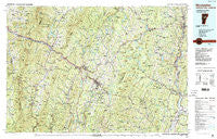
~ Montpelier VT topo map, 1:100000 scale, 30 X 60 Minute, Historical, 1988, updated 1989
Montpelier, Vermont, USGS topographic map dated 1988.
Includes geographic coordinates (latitude and longitude). This topographic map is suitable for hiking, camping, and exploring, or framing it as a wall map.
Printed on-demand using high resolution imagery, on heavy weight and acid free paper, or alternatively on a variety of synthetic materials.
Topos available on paper, Waterproof, Poly, or Tyvek. Usually shipping rolled, unless combined with other folded maps in one order.
- Product Number: USGS-5600690
- Free digital map download (high-resolution, GeoPDF): Montpelier, Vermont (file size: 38 MB)
- Map Size: please refer to the dimensions of the GeoPDF map above
- Weight (paper map): ca. 55 grams
- Map Type: POD USGS Topographic Map
- Map Series: HTMC
- Map Verison: Historical
- Cell ID: 67981
- Scan ID: 338229
- Imprint Year: 1989
- Woodland Tint: Yes
- Aerial Photo Year: 1986
- Edit Year: 1988
- Datum: NAD27
- Map Projection: Universal Transverse Mercator
- Map published by United States Geological Survey
- Map Language: English
- Scanner Resolution: 600 dpi
- Map Cell Name: Montpelier
- Grid size: 30 X 60 Minute
- Date on map: 1988
- Map Scale: 1:100000
- Geographical region: Vermont, United States
Neighboring Maps:
All neighboring USGS topo maps are available for sale online at a variety of scales.
Spatial coverage:
Topo map Montpelier, Vermont, covers the geographical area associated the following places:
- Edgewater - Middlesex - South Barre - Greenbank Hollow - Green Bay - Irasville - Saint Johnsbury - Nevesville - South Peacham - East Ryegate - East Warren - East Barre - Waits River - Taylor Bridge - Alpine Village - Moretown - South Cabot - Cabot - North Fayston - Lincoln - Lakeside - Waitsfield Common - East Brookfield - South Ryegate - Pumpkin Hill (historical) - South Lincoln - Moscow - Maple Corner - East Roxbury - Dowsville - Wrightsville - Waterbury - Lanesboro - Northfield - Kennedy Corners - East Montpelier Center - Upper Graniteville - East Corinth - Smith Corner - Washington - Perkinsville - Waterbury Center - East Peacham - Lower Village - South Duxbury - Goshen - Peacham - Duxbury - Shady Rill - Foxville - Mill Village - North Calais - Coles Corner - North Duxbury - Washington Heights - Groton - Colbyville - South Northfield - Downingville - Richmond - Peach Four Corners - East Orange - South Walden - Brookfield Center - Corinth Corner - East Barnet Inwood Station - Wildersburg Common - Plainfield - West Berlin - Orange - Mosquitoville - South Corinth - Morses Mills - Hanksville - Ewells Mills - Danville Center - Putnamville - Berlin Corners - Bradford Center - Boltonville - West Newbury - Cookville - North Haverhill - Nashville - Woodbury - Ricker Mills - Lower Websterville - Walden - Corinth Corners - Passumpsic - East Calais - Worcester - Northfield Falls - North Moretown - McIndoe Falls - Stowe - West Corinth - East Montpelier - Graniteville - South Woodbury
- Map Area ID: AREA44.544-73-72
- Northwest corner Lat/Long code: USGSNW44.5-73
- Northeast corner Lat/Long code: USGSNE44.5-72
- Southwest corner Lat/Long code: USGSSW44-73
- Southeast corner Lat/Long code: USGSSE44-72
- Northern map edge Latitude: 44.5
- Southern map edge Latitude: 44
- Western map edge Longitude: -73
- Eastern map edge Longitude: -72


