
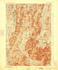
~ Pawlet VT topo map, 1:62500 scale, 15 X 15 Minute, Historical, 1897, updated 1924
Pawlet, Vermont, USGS topographic map dated 1897.
Includes geographic coordinates (latitude and longitude). This topographic map is suitable for hiking, camping, and exploring, or framing it as a wall map.
Printed on-demand using high resolution imagery, on heavy weight and acid free paper, or alternatively on a variety of synthetic materials.
Topos available on paper, Waterproof, Poly, or Tyvek. Usually shipping rolled, unless combined with other folded maps in one order.
- Product Number: USGS-5600474
- Free digital map download (high-resolution, GeoPDF): Pawlet, Vermont (file size: 13 MB)
- Map Size: please refer to the dimensions of the GeoPDF map above
- Weight (paper map): ca. 55 grams
- Map Type: POD USGS Topographic Map
- Map Series: HTMC
- Map Verison: Historical
- Cell ID: 60819
- Scan ID: 338108
- Imprint Year: 1924
- Survey Year: 1894
- Datum: NAD
- Map Projection: Polyconic
- Map published by United States Geological Survey
- Map Language: English
- Scanner Resolution: 600 dpi
- Map Cell Name: Pawlet
- Grid size: 15 X 15 Minute
- Date on map: 1897
- Map Scale: 1:62500
- Geographical region: Vermont, United States
Neighboring Maps:
All neighboring USGS topo maps are available for sale online at a variety of scales.
Spatial coverage:
Topo map Pawlet, Vermont, covers the geographical area associated the following places:
- Burnham Hollow - South Poultney - Tinmouth - Freedleyville - West Tinmouth - North Rupert - Rupert - Butternut - North Dorset - Scottsville - Dorset - North Pawlet - East Rupert - Danby Four Corners - Wells - Middletown Springs - Pawlet - East Wells
- Map Area ID: AREA43.543.25-73.25-73
- Northwest corner Lat/Long code: USGSNW43.5-73.25
- Northeast corner Lat/Long code: USGSNE43.5-73
- Southwest corner Lat/Long code: USGSSW43.25-73.25
- Southeast corner Lat/Long code: USGSSE43.25-73
- Northern map edge Latitude: 43.5
- Southern map edge Latitude: 43.25
- Western map edge Longitude: -73.25
- Eastern map edge Longitude: -73


