
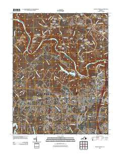
~ Salem Church VA topo map, 1:24000 scale, 7.5 X 7.5 Minute, Historical, 2011
Salem Church, Virginia, USGS topographic map dated 2011.
Includes geographic coordinates (latitude and longitude). This topographic map is suitable for hiking, camping, and exploring, or framing it as a wall map.
Printed on-demand using high resolution imagery, on heavy weight and acid free paper, or alternatively on a variety of synthetic materials.
Topos available on paper, Waterproof, Poly, or Tyvek. Usually shipping rolled, unless combined with other folded maps in one order.
- Product Number: USGS-5466523
- Free digital map download (high-resolution, GeoPDF): Salem Church, Virginia (file size: 23 MB)
- Map Size: please refer to the dimensions of the GeoPDF map above
- Weight (paper map): ca. 55 grams
- Map Type: POD USGS Topographic Map
- Map Series: US Topo
- Map Verison: Historical
- Cell ID: 39434
- Datum: North American Datum of 1983
- Map Projection: Transverse Mercator
- Map Cell Name: Salem Church
- Grid size: 7.5 X 7.5 Minute
- Date on map: 2011
- Map Scale: 1:24000
- Geographical region: Virginia, United States
Neighboring Maps:
All neighboring USGS topo maps are available for sale online at a variety of scales.
Spatial coverage:
Topo map Salem Church, Virginia, covers the geographical area associated the following places:
- Meadows Park - Rivergate - Foxwood Estates - Old Banks - Mansfield Manor - Five Mile Fork - River Ridge Estates - Warrenton Center - Heartland Ridge - Wallaces Corner - Walnut Grove - Waverly Village - Holly Acres - Wellington Chase on the Rappahannock - Chancellor - Peach Lawn - Snead Estates - Mine Ridge - Monroe Farm - England Run - Scenic Ridge - Berea Plantation - Holly Run Estates - Berea - Monroe Estates - Maple Grove Estates - Berea Estates - English Hills - Cardinal Forest - Quiet Woods Estate - Mars Mobile Home Park - Nora Park - Chapalita - Kimberly Estates - Summerset Ridge - Holly Corner - Woodridge - Holly Corner Estates - Stafford Lakes Village - Berry Hill Estates - Woodlands at Berea - Holly Corners
- Map Area ID: AREA38.37538.25-77.625-77.5
- Northwest corner Lat/Long code: USGSNW38.375-77.625
- Northeast corner Lat/Long code: USGSNE38.375-77.5
- Southwest corner Lat/Long code: USGSSW38.25-77.625
- Southeast corner Lat/Long code: USGSSE38.25-77.5
- Northern map edge Latitude: 38.375
- Southern map edge Latitude: 38.25
- Western map edge Longitude: -77.625
- Eastern map edge Longitude: -77.5


