
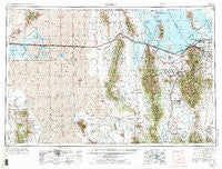
~ Tooele UT topo map, 1:250000 scale, 1 X 2 Degree, Historical, 1953, updated 1973
Tooele, Utah, USGS topographic map dated 1953.
Includes geographic coordinates (latitude and longitude). This topographic map is suitable for hiking, camping, and exploring, or framing it as a wall map.
Printed on-demand using high resolution imagery, on heavy weight and acid free paper, or alternatively on a variety of synthetic materials.
Topos available on paper, Waterproof, Poly, or Tyvek. Usually shipping rolled, unless combined with other folded maps in one order.
- Product Number: USGS-5463471
- Free digital map download (high-resolution, GeoPDF): Tooele, Utah (file size: 24 MB)
- Map Size: please refer to the dimensions of the GeoPDF map above
- Weight (paper map): ca. 55 grams
- Map Type: POD USGS Topographic Map
- Map Series: HTMC
- Map Verison: Historical
- Cell ID: 75005
- Scan ID: 252472
- Imprint Year: 1973
- Woodland Tint: Yes
- Visual Version Number: 2
- Photo Revision Year: 1970
- Aerial Photo Year: 1953
- Datum: Unstated
- Map Projection: Transverse Mercator
- Map published by United States Geological Survey
- Map Language: English
- Scanner Resolution: 600 dpi
- Map Cell Name: Tooele
- Grid size: 1 X 2 Degree
- Date on map: 1953
- Map Scale: 1:250000
- Geographical region: Utah, United States
Neighboring Maps:
All neighboring USGS topo maps are available for sale online at a variety of scales.
Spatial coverage:
Topo map Tooele, Utah, covers the geographical area associated the following places:
- Linford Acres - Sundown - Oquirrh Hills Subdivision 5, 6, 8 and 9 - Shadow Run Estates - Deerfield - Eggli Acres - Westridge - Vernon - Copper Cove - Higate Hamlet - Copper Cove Condominium - Maplewood Addition - Bacchus - King Valley - Springbrook - Powderwood Estates - Green Meadows Estates - Den-Mar - Grantsville - Chambers Park - Dolomite - Southfork - Sundown - Dugway - Day Park Estates - Rush Valley - Ophir - Browns Townsite - Suncrest - Martin Village - Orchard View - Vega Park - Timpie - Terra - B and B Estates - Revella Park - Kimberly Crest - Colony West Subdivision - Numbers 13, 14 and 15 - Mac Sweeney Estates - Saint John - Topliff - Copper Hill Heights Twelve - Fairfield - Pleasant Green Acres Subdivision 3-9 - Spencers Annex - Delta Park - Flangas - Chambers Townsite - Amanda Acres - Valley View Park - Copper Hills Heights - Lake Point Junction - Mallard - Stansbury park - Kevinwood Estates - Burkes Addition - Marshall - Huntington Place - Chris Acres - Bacchus Heights - Ibapah - Angels Grove - Tooele - Hunter Village Condominium - Catalina Estates - Whites Way - Walnut Hills - Lakato Estates - Woodledge - Brook Hollow - Robbe - Progress - Lofgreen - Crestview - Iosepa (historical) - Contadora Estates - Erda - Oquirlane - Majestic Acres - Country West - Condie Park Estates - Larsen Estates - Westview Terrace - Cyprus Heights - Brookhaven - Sunny Side - Thomas Gardens - Sutton Estates - Lago - Dial Heights - West Hills - Hoffman Heights - Aragonite - Copper Hill Heights Nine and Ten - Copper City - Sue Ann - West Mercur - Bonneville Ridge - Low - Pehrson
- Map Area ID: AREA4140-114-112
- Northwest corner Lat/Long code: USGSNW41-114
- Northeast corner Lat/Long code: USGSNE41-112
- Southwest corner Lat/Long code: USGSSW40-114
- Southeast corner Lat/Long code: USGSSE40-112
- Northern map edge Latitude: 41
- Southern map edge Latitude: 40
- Western map edge Longitude: -114
- Eastern map edge Longitude: -112


