
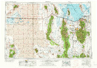
~ Tooele UT topo map, 1:250000 scale, 1 X 2 Degree, Historical, 1953, updated 1973
Tooele, Utah, USGS topographic map dated 1953.
Includes geographic coordinates (latitude and longitude). This topographic map is suitable for hiking, camping, and exploring, or framing it as a wall map.
Printed on-demand using high resolution imagery, on heavy weight and acid free paper, or alternatively on a variety of synthetic materials.
Topos available on paper, Waterproof, Poly, or Tyvek. Usually shipping rolled, unless combined with other folded maps in one order.
- Product Number: USGS-5463468
- Free digital map download (high-resolution, GeoPDF): Tooele, Utah (file size: 24 MB)
- Map Size: please refer to the dimensions of the GeoPDF map above
- Weight (paper map): ca. 55 grams
- Map Type: POD USGS Topographic Map
- Map Series: HTMC
- Map Verison: Historical
- Cell ID: 75005
- Scan ID: 252471
- Imprint Year: 1973
- Woodland Tint: Yes
- Visual Version Number: 1
- Photo Revision Year: 1970
- Aerial Photo Year: 1953
- Datum: Unstated
- Map Projection: Transverse Mercator
- Map published by United States Geological Survey
- Map Language: English
- Scanner Resolution: 600 dpi
- Map Cell Name: Tooele
- Grid size: 1 X 2 Degree
- Date on map: 1953
- Map Scale: 1:250000
- Geographical region: Utah, United States
Neighboring Maps:
All neighboring USGS topo maps are available for sale online at a variety of scales.
Spatial coverage:
Topo map Tooele, Utah, covers the geographical area associated the following places:
- Bacchus - Bailey - Woodledge - Century Condominium - Riter - Chambers Townsite - Hunter Heights - Faust - Pleasant Valley - Westview Terrace - Kimberly Crest - West Mercur - Magna - Deerfield - Pleasant Green Acres Subdivision 3-9 - Hunter Stake - Blair - Bailey Meadows - Damron Way - Equestrian Springs - Hunter Hills - Woodbury Estates - Flux - Huntington Place - Indian Village - Highland - Mac Sweeney Estates - Silsbee - Whites Way - Sunset Downs - Mountain Men Estates - Wane/Match - Polaris Gardens - Cherill Acres - Chaparral West - Amanda Acres - Centennial Village - Garden Lot Addition - Fairfield - Centennial Village Two - Teasel Downs - Clive - Kopper View Mobile Home Park - Contadora Estates - Copper Hills Heights - Topliff - Sunset Hills - Chaparral Estates - Lakato Estates - Iosepa (historical) - Royal West - Stockton - Crestview - Robbe - Condie - Sue Ann - Western Sun - Higate Hamlet - Terra - Brady Place - Salt Lake International Center - Terminal - Majestic Acres - Thompson Acres - Magna Manors - Bonneville Ridge - April Acres - Chantilly - Flangas - Spencers Annex - Delle - Family Estates - Chris Acres - Timpie - Progress - Oquirlane - Den-Mar Condominium - Linford Acres - Maplewood Addition - Copper View Estates - Browns Townsite - Shadow Run Estates - Chambers Park - Delta Park - Hunter - Lake Point - Hopkins Meadows - Pehrson - Addison Park One - Center - Dalton - Magna Addition - Rush Valley - Hi Country Estates - Bonneville Acres - Clifton - Bello Park - El Dorado - Bauer - Hill Gate
- Map Area ID: AREA4140-114-112
- Northwest corner Lat/Long code: USGSNW41-114
- Northeast corner Lat/Long code: USGSNE41-112
- Southwest corner Lat/Long code: USGSSW40-114
- Southeast corner Lat/Long code: USGSSE40-112
- Northern map edge Latitude: 41
- Southern map edge Latitude: 40
- Western map edge Longitude: -114
- Eastern map edge Longitude: -112


