
~ Salina UT topo map, 1:250000 scale, 1 X 2 Degree, Historical, 1960
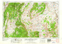
Salina, Utah, USGS topographic map dated 1960.
Includes geographic coordinates (latitude and longitude). This topographic map is suitable for hiking, camping, and exploring, or framing it as a wall map.
Printed on-demand using high resolution imagery, on heavy weight and acid free paper, or alternatively on a variety of synthetic materials.
Topos available on paper, Waterproof, Poly, or Tyvek. Usually shipping rolled, unless combined with other folded maps in one order.
- Product Number: USGS-5463438
- Free digital map download (high-resolution, GeoPDF): Salina, Utah (file size: 21 MB)
- Map Size: please refer to the dimensions of the GeoPDF map above
- Weight (paper map): ca. 55 grams
- Map Type: POD USGS Topographic Map
- Map Series: HTMC
- Map Verison: Historical
- Cell ID: 74992
- Scan ID: 251634
- Woodland Tint: Yes
- Aerial Photo Year: 1956
- Datum: Unstated
- Map Projection: Transverse Mercator
- Map published by United States Army Corps of Engineers
- Map published by United States Army
- Map Language: English
- Scanner Resolution: 600 dpi
- Map Cell Name: Salina
- Grid size: 1 X 2 Degree
- Date on map: 1960
- Map Scale: 1:250000
- Geographical region: Utah, United States
Neighboring Maps:
All neighboring USGS topo maps are available for sale online at a variety of scales.
Spatial coverage:
Topo map Salina, Utah, covers the geographical area associated the following places:
- Glenwood - Whipup - Burrville - Aurora - Notom - Teasdale - Fremont Junction - Antimony - Moore - Elgin - Lyman - Osiris - Fruita - Hanksville - Koosharem - Fishlake Resort - Caineville - Solitude - Torrey - Greenwich - Lone Tree Crossing - Green River - Loa - Vermillion - Lakeside Resort - Angle - Salina - Grover - Emery - Bicknell - Sigurd - Fremont
- Map Area ID: AREA3938-112-110
- Northwest corner Lat/Long code: USGSNW39-112
- Northeast corner Lat/Long code: USGSNE39-110
- Southwest corner Lat/Long code: USGSSW38-112
- Southeast corner Lat/Long code: USGSSE38-110
- Northern map edge Latitude: 39
- Southern map edge Latitude: 38
- Western map edge Longitude: -112
- Eastern map edge Longitude: -110


