
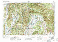
~ Price UT topo map, 1:250000 scale, 1 X 2 Degree, Historical, 1956, updated 1973
Price, Utah, USGS topographic map dated 1956.
Includes geographic coordinates (latitude and longitude). This topographic map is suitable for hiking, camping, and exploring, or framing it as a wall map.
Printed on-demand using high resolution imagery, on heavy weight and acid free paper, or alternatively on a variety of synthetic materials.
Topos available on paper, Waterproof, Poly, or Tyvek. Usually shipping rolled, unless combined with other folded maps in one order.
- Product Number: USGS-5463423
- Free digital map download (high-resolution, GeoPDF): Price, Utah (file size: 27 MB)
- Map Size: please refer to the dimensions of the GeoPDF map above
- Weight (paper map): ca. 55 grams
- Map Type: POD USGS Topographic Map
- Map Series: HTMC
- Map Verison: Historical
- Cell ID: 74997
- Scan ID: 251404
- Imprint Year: 1973
- Woodland Tint: Yes
- Visual Version Number: 1
- Aerial Photo Year: 1955
- Edit Year: 1970
- Datum: Unstated
- Map Projection: Transverse Mercator
- Map published by: Military, Other
- Map Language: English
- Scanner Resolution: 600 dpi
- Map Cell Name: Price
- Grid size: 1 X 2 Degree
- Date on map: 1956
- Map Scale: 1:250000
- Geographical region: Utah, United States
Neighboring Maps:
All neighboring USGS topo maps are available for sale online at a variety of scales.
Spatial coverage:
Topo map Price, Utah, covers the geographical area associated the following places:
- Gilluly - Gypsum Mill - Genola - Beaver Dams Summer Homes Area - Hill Top - Standardville - Jerusalem - West Ephraim - Martin - Price - Victor - Helper - Spring Glen - Centerfield - Nephi - Latuda - Columbia - Cleveland - Fountain Green - Huntington - Sky View (historical) - Peerless - Sunnyside Junction - Castle Dale - Sunnyside - Sunnydale - Indianola - Cedar - Ferron - Pines - Mount Nebo - Wattis - Pigeon Hollow Junction - Mona - Elmo - East Carbon City - Columbia Junction - Royal - Lant - Mayfield - Kenilworth - Dragerton - Spring City - Manti - Chester - Moroni - Ferron Mill - Soldier Summit - Orangeville - Birdseye - Redmond - Christianburg - Goshen - Consumers - Gunnison - Coal City - Carbonville - Tucker (historical) - Winter Quarters (historical) - Spearmint - Milburn - Castle Gate (historical) - Bruin Point - Clear Creek - Heiner - Mohrland - Starr - Molen - Kyune - Colton - Rocky Ridge - Woodside - Townsend - Rio - Wildcat - Fairview - Ephraim - Fayette - Storrs - Desert - Freedom - Mount Pleasant - Oak Creek - Santaquin - Wales - Wattis Junction - Horse Canyon - Mill Fork - Lawrence - Juab - Levan - Axtell - Hiawatha - Sharp - Three Forks - Wellington - Scofield - Clawson - Upper Sunnyside - Wood Hill
- Map Area ID: AREA4039-112-110
- Northwest corner Lat/Long code: USGSNW40-112
- Northeast corner Lat/Long code: USGSNE40-110
- Southwest corner Lat/Long code: USGSSW39-112
- Southeast corner Lat/Long code: USGSSE39-110
- Northern map edge Latitude: 40
- Southern map edge Latitude: 39
- Western map edge Longitude: -112
- Eastern map edge Longitude: -110


