
~ Ogden UT topo map, 1:250000 scale, 1 X 2 Degree, Historical, 1954, updated 1983
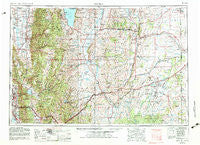
Ogden, Utah, USGS topographic map dated 1954.
Includes geographic coordinates (latitude and longitude). This topographic map is suitable for hiking, camping, and exploring, or framing it as a wall map.
Printed on-demand using high resolution imagery, on heavy weight and acid free paper, or alternatively on a variety of synthetic materials.
Topos available on paper, Waterproof, Poly, or Tyvek. Usually shipping rolled, unless combined with other folded maps in one order.
- Product Number: USGS-5463411
- Free digital map download (high-resolution, GeoPDF): Ogden, Utah (file size: 22 MB)
- Map Size: please refer to the dimensions of the GeoPDF map above
- Weight (paper map): ca. 55 grams
- Map Type: POD USGS Topographic Map
- Map Series: HTMC
- Map Verison: Historical
- Cell ID: 68944
- Scan ID: 251077
- Imprint Year: 1983
- Woodland Tint: Yes
- Aerial Photo Year: 1978
- Edit Year: 1982
- Field Check Year: 1954
- Datum: NAD27
- Map Projection: Transverse Mercator
- Map published by United States Geological Survey
- Map Language: English
- Scanner Resolution: 600 dpi
- Map Cell Name: Ogden
- Grid size: 1 X 2 Degree
- Date on map: 1954
- Map Scale: 1:250000
- Geographical region: Utah, United States
Neighboring Maps:
All neighboring USGS topo maps are available for sale online at a variety of scales.
Spatial coverage:
Topo map Ogden, Utah, covers the geographical area associated the following places:
- Kingston Heights Addition - Liberty - Williams - Jo Lu - Liberty Bell Ranchettes - Protzman - Oakridge Farms - Pleasant View - Fairway Fields - South Fork Ranchettes - Altamont - Burch Creek - Cottonwood Heights - Woodland Estates - Country Hollow - Call - Academy Heights Addition - Middle Fork Ranches - Fort Bridger - Bonnie Lane Condominium - Hillside Estates - Ben Lomond Heights - Hods Hollow - Childs Addition - Church Hills - Mountain View Addition - Ridgeview Park - Burch Addition - Phillips - Bridger - El-May Park Addition - Albertsons Center - Aura Acres - Eastgrove Condominium Phase 2-7 - Larson Park - Hill Top - Oxford Place - Olympus Heights - Central Park Addition - Tanglewood - Crestwood Acres - Aspen - Mystic Mountain - Nelson Park Addition - Bailey - Mountain Valley Meadows - Uintah Village - Emerson Addition - Green Leaf Meadows - Country Estates - Rolling Greens - Elkhurst - View Heights - Hartman - East Lynne Addition - Mutton Hollow Meadows - Capitol Block Addition - Edgemont - Kissock - Briarwood Condominium - Nob Hill Addition - Haven Park - Ron Clare Village - Lark Circle - Myers Addition - Eastwood Subdivision Number 5 - Whispering Oaks - Richville - Hoff - Country Hills Manor Condominiums - Gill - Bonneville Terrace Number One - Victorian Oaks - Camelot - Shanna - Cornish - Country Meadows - Beus Hills - Millburne - City Park Addition - Spencer Estates - Fairmont - El Monte Vista - Mountain Estates - Ridgepoint - Cross - The Heights Condominium - Mountain Terrace Subdivision Number 1-4 - College Ward - Gardens of Eden - Quail Hollow - Bonneville Heights - Mount Lewis - Mountain Valley Ranchettes - Rogers Park - Circle View - Charlesworth Addition - Taylor Estates - Paradise Hills - LaDonna Mesa
- Map Area ID: AREA4241-112-110
- Northwest corner Lat/Long code: USGSNW42-112
- Northeast corner Lat/Long code: USGSNE42-110
- Southwest corner Lat/Long code: USGSSW41-112
- Southeast corner Lat/Long code: USGSSE41-110
- Northern map edge Latitude: 42
- Southern map edge Latitude: 41
- Western map edge Longitude: -112
- Eastern map edge Longitude: -110


