
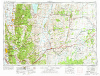
~ Ogden UT topo map, 1:250000 scale, 1 X 2 Degree, Historical, 1954, updated 1975
Ogden, Utah, USGS topographic map dated 1954.
Includes geographic coordinates (latitude and longitude). This topographic map is suitable for hiking, camping, and exploring, or framing it as a wall map.
Printed on-demand using high resolution imagery, on heavy weight and acid free paper, or alternatively on a variety of synthetic materials.
Topos available on paper, Waterproof, Poly, or Tyvek. Usually shipping rolled, unless combined with other folded maps in one order.
- Product Number: USGS-5463404
- Free digital map download (high-resolution, GeoPDF): Ogden, Utah (file size: 21 MB)
- Map Size: please refer to the dimensions of the GeoPDF map above
- Weight (paper map): ca. 55 grams
- Map Type: POD USGS Topographic Map
- Map Series: HTMC
- Map Verison: Historical
- Cell ID: 68944
- Scan ID: 251072
- Imprint Year: 1975
- Woodland Tint: Yes
- Aerial Photo Year: 1954
- Edit Year: 1966
- Datum: Unstated
- Map Projection: Transverse Mercator
- Map published by United States Geological Survey
- Map published by United States Army Corps of Engineers
- Map published by United States Army
- Map Language: English
- Scanner Resolution: 600 dpi
- Map Cell Name: Ogden
- Grid size: 1 X 2 Degree
- Date on map: 1954
- Map Scale: 1:250000
- Geographical region: Utah, United States
Neighboring Maps:
All neighboring USGS topo maps are available for sale online at a variety of scales.
Spatial coverage:
Topo map Ogden, Utah, covers the geographical area associated the following places:
- Hillcrest Addition - Green View - The Orchard - Melody Lane - Central Park Addition - Mount Dell - City Park Addition - Gill - Trenton - Cherry Farm Estates - Twin Creek Estates - Manhattan - Jumpoff Canyon - Island View Acres - Shadow Valley Estates - Cornish - Southridge Subdivision 2 - Quail Run - Laker Lane Condominium - Hassell Heights - Willow Addition - Elkhurst - Vera Lee - Stein - Mountain Oaks Estates Number 2 - Cherry Lane Heights - Colonial Park - W S Butler - Emerson Main Street Addition - Rolling Greens - Mount Sterling - Sun View Additions 1-3 - Wolf Creek Village - Church Hills - Laker - Harbertson - Victory Park - Heritage Grove - Fernwood Hollow - Deerwalk Single Unit Condominium - Oak Hills - Taylors Addition - Paradise Acres - Argonne Park - Mountain Estates - West Layton - Green Briar West - Liberty - Hidden Hollow - Mount Lewis - Blazon Junction - Rayann - Golden View - Pearwood Park - Rogers Park - Powder Mountain West - De Bloois - Patio Springs - Kimberly Meadows - Willow Creek - Saunders - Garfield Addition - Oak Ridge Acres - East Ridge - West Ogden - Marketboro - Woodfield Estates - Stettler - Greens Corner - Naisbitt - Massa - Leefe - Somerset Place Condominium - Logan - Mar Lon Hills Number One - Skyline Estates - Emerald Hills Condominium - Church Hill Estates - Hunters - Kent Estates - Farmington Orchards - Country Estates - Cobble Creek Park - Piedmont - Ogden Canyon Wildwood Estates - Fairmount - Townside Park - Jo Lu - Robertson - The Meadows PRUD - Laketown - Arlington Heights - Millburne - Three Forks - Robins Park One and Two - Heatherglen - Rockefeller - Lake Hills - Antelope - Ironwood
- Map Area ID: AREA4241-112-110
- Northwest corner Lat/Long code: USGSNW42-112
- Northeast corner Lat/Long code: USGSNE42-110
- Southwest corner Lat/Long code: USGSSW41-112
- Southeast corner Lat/Long code: USGSSE41-110
- Northern map edge Latitude: 42
- Southern map edge Latitude: 41
- Western map edge Longitude: -112
- Eastern map edge Longitude: -110


