
~ Escalante UT topo map, 1:250000 scale, 1 X 2 Degree, Historical, 1956, updated 1971
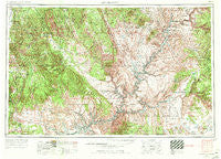
Escalante, Utah, USGS topographic map dated 1956.
Includes geographic coordinates (latitude and longitude). This topographic map is suitable for hiking, camping, and exploring, or framing it as a wall map.
Printed on-demand using high resolution imagery, on heavy weight and acid free paper, or alternatively on a variety of synthetic materials.
Topos available on paper, Waterproof, Poly, or Tyvek. Usually shipping rolled, unless combined with other folded maps in one order.
- Product Number: USGS-5463379
- Free digital map download (high-resolution, GeoPDF): Escalante, Utah (file size: 23 MB)
- Map Size: please refer to the dimensions of the GeoPDF map above
- Weight (paper map): ca. 55 grams
- Map Type: POD USGS Topographic Map
- Map Series: HTMC
- Map Verison: Historical
- Cell ID: 74985
- Scan ID: 249198
- Imprint Year: 1971
- Woodland Tint: Yes
- Aerial Photo Year: 1955
- Edit Year: 1970
- Datum: Unstated
- Map Projection: Transverse Mercator
- Map published by United States Geological Survey
- Map Language: English
- Scanner Resolution: 600 dpi
- Map Cell Name: Escalante
- Grid size: 1 X 2 Degree
- Date on map: 1956
- Map Scale: 1:250000
- Geographical region: Utah, United States
Neighboring Maps:
All neighboring USGS topo maps are available for sale online at a variety of scales.
Spatial coverage:
Topo map Escalante, Utah, covers the geographical area associated the following places:
- Halls Crossing - White Canyon (historical) - Gravel Crossing - Ticaboo - Widtsoe - Goulding - Rainbow City - Ducket Crossing - Eggnog - Fry Canyon - Clay Hills Crossing - Escalante - Hite (historical) - Henrieville - Soldier Crossing - Big Water - Paria - Navajo Mountain - Oljato - Three Forks - Boulder Town
- Map Area ID: AREA3837-112-110
- Northwest corner Lat/Long code: USGSNW38-112
- Northeast corner Lat/Long code: USGSNE38-110
- Southwest corner Lat/Long code: USGSSW37-112
- Southeast corner Lat/Long code: USGSSE37-110
- Northern map edge Latitude: 38
- Southern map edge Latitude: 37
- Western map edge Longitude: -112
- Eastern map edge Longitude: -110


