
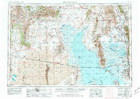
~ Brigham City UT topo map, 1:250000 scale, 1 X 2 Degree, Historical, 1954, updated 1981
Brigham City, Utah, USGS topographic map dated 1954.
Includes geographic coordinates (latitude and longitude). This topographic map is suitable for hiking, camping, and exploring, or framing it as a wall map.
Printed on-demand using high resolution imagery, on heavy weight and acid free paper, or alternatively on a variety of synthetic materials.
Topos available on paper, Waterproof, Poly, or Tyvek. Usually shipping rolled, unless combined with other folded maps in one order.
- Product Number: USGS-5463344
- Free digital map download (high-resolution, GeoPDF): Brigham City, Utah (file size: 23 MB)
- Map Size: please refer to the dimensions of the GeoPDF map above
- Weight (paper map): ca. 55 grams
- Map Type: POD USGS Topographic Map
- Map Series: HTMC
- Map Verison: Historical
- Cell ID: 68689
- Scan ID: 248297
- Imprint Year: 1981
- Woodland Tint: Yes
- Aerial Photo Year: 1953
- Edit Year: 1970
- Datum: NAD27
- Map Projection: Transverse Mercator
- Map published by United States Geological Survey
- Map Language: English
- Scanner Resolution: 600 dpi
- Map Cell Name: Brigham City
- Grid size: 1 X 2 Degree
- Date on map: 1954
- Map Scale: 1:250000
- Geographical region: Utah, United States
Neighboring Maps:
All neighboring USGS topo maps are available for sale online at a variety of scales.
Spatial coverage:
Topo map Brigham City, Utah, covers the geographical area associated the following places:
- Westridge - Brimhall Estates - Stevens Estates - Carriage Place - Villa Moritz - Naisbitt Acres - Maplewood Estates - Cedar Ridge - Roy - John Fuit - Harveys Redwood Estates - Bel Air - Great Basin Addition - Bingham Estates - Reese - Valley Green Estates - Campbell Heights - Rosehill - Corinne - Crossroads - Anderson West Acres - Taylor - Kelley Kay Acres - Country Estates Park - Barlow Heights - Country Place - Saline - Town and Country Estates - Garden Acres - Howell - Pleasant View - Riverside - Stuart - Jones - Ranchettes West - Yorkshire Place - Purser - Smedley Acres - Park Lake - English Manor - Wheeler Village Unit One - Perry - Garland - Hooper - Interwest Condominium Project Phase A - Linda Vista - Glade Nielsen - Suntrails - Valley Side - Lakeside Park - Marvins - Newport Haven - Layton Park - Sunray - Heritage Estates - Christensen - Lakeview Gardens - Smith Village - Harmony Park - New Hampton Manor - Plymouth - Curlew Junction - Westwood Estates - Par Four - Westmond Condominium - Hardup - Eves Garden - Bel-Aire Condominium - Nerva - Rosette - Collinston - Bellevue Place - Midland Farms - Oakcrest Estates - Elta Glen - Apple Park - Olivewood Park - Pioneer Village - Brigham City - Herefordshire Condominium - Deweyville - Snap-N-Fox Farms - Alpine Ranchettes - Midland Square - Relico - Clearfield Heights - White - Blue Creek - Golden West Villa - Allen Taylor - Edgehill Estates - Hills of Homes - The Parsons Place - Westbrook - Kristalyn Gardens - Lou-vre Estates - Montrose Park - Marriott - Sunrise Park - Fairway Estates
- Map Area ID: AREA4241-114-112
- Northwest corner Lat/Long code: USGSNW42-114
- Northeast corner Lat/Long code: USGSNE42-112
- Southwest corner Lat/Long code: USGSSW41-114
- Southeast corner Lat/Long code: USGSSE41-112
- Northern map edge Latitude: 42
- Southern map edge Latitude: 41
- Western map edge Longitude: -114
- Eastern map edge Longitude: -112


