
~ Brigham City UT topo map, 1:250000 scale, 1 X 2 Degree, Historical, 1958
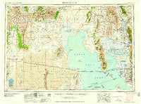
Brigham City, Utah, USGS topographic map dated 1958.
Includes geographic coordinates (latitude and longitude). This topographic map is suitable for hiking, camping, and exploring, or framing it as a wall map.
Printed on-demand using high resolution imagery, on heavy weight and acid free paper, or alternatively on a variety of synthetic materials.
Topos available on paper, Waterproof, Poly, or Tyvek. Usually shipping rolled, unless combined with other folded maps in one order.
- Product Number: USGS-5463336
- Free digital map download (high-resolution, GeoPDF): Brigham City, Utah (file size: 19 MB)
- Map Size: please refer to the dimensions of the GeoPDF map above
- Weight (paper map): ca. 55 grams
- Map Type: POD USGS Topographic Map
- Map Series: HTMC
- Map Verison: Historical
- Cell ID: 68689
- Scan ID: 248291
- Woodland Tint: Yes
- Aerial Photo Year: 1953
- Datum: Unstated
- Map Projection: Transverse Mercator
- Map published by United States Geological Survey
- Map published by United States Army Corps of Engineers
- Map Language: English
- Scanner Resolution: 600 dpi
- Map Cell Name: Brigham City
- Grid size: 1 X 2 Degree
- Date on map: 1958
- Map Scale: 1:250000
- Geographical region: Utah, United States
Neighboring Maps:
All neighboring USGS topo maps are available for sale online at a variety of scales.
Spatial coverage:
Topo map Brigham City, Utah, covers the geographical area associated the following places:
- The Hillsite Addition - Glade Nielsen - Herefordshire - Fawcett - Hatch - Fairway Estates - Little Mountain - Kanesville - West Haven - Kentwood Condominium - Quail Point - Pinto Acres - Coy - Southwood - Jones - Terry Estates - Willard - La Loma - Villa Moritz - Rosehill - Lucin - Glade-Nelson - Thornleys - Bellevue Place - Hills of Homes - Muir Meadows - Wen Dale Park - Sandalwood Square - Villa Vista - Pleasant View - Grouse Creek Junction - West View Park - Bay View Park - Snap-N-Fox Farms - C C Ann Estates - Sky West Estates - Harmony Park - Bel-Aire Condominium - Tri-S Village Estates - New Hampton Manor - Valley Park Estates - Tubbs - Roskelley - Melanie Acres - Green Hill Acres - Equestrian Ranchettes - Ogden Heights - West Sunset View Estates - Commonwealth Square Condominium - Honeyville - Pratts - Gilene - Relico - Margretta - Kentwood Estates - Herefordshire Condominium - Lakeside - Garland - North Crest Manor - Steed - Holley and Whitney - English Manor - Plain City - Riverdale - Madsen - Harveys Redwood Estates - Standrod - Garden Acres - Lakeview Gardens - Cottonwood Meadows - Diamond Hills - Willow Wood - Country Estates Park - Jill - Valley West Estates - Anderson West Acres - Hardup - Peppermint Park - Buena Vista - Lewis Estates - Jackson Acres - Bothwell - Rosewood Manor Condominium - Parkside - Farr West - Katies Place - Airlane Park - Smith Village - Oakcrest Estates - Bear River City - Bonham - Lou-vre Estates - Freedom Acres - Bel Air - Clint Village - William R Patterson - Colonial Gardens Condominium - Mel Stephenson - Buena Vista - Maplewood Estates
- Map Area ID: AREA4241-114-112
- Northwest corner Lat/Long code: USGSNW42-114
- Northeast corner Lat/Long code: USGSNE42-112
- Southwest corner Lat/Long code: USGSSW41-114
- Southeast corner Lat/Long code: USGSSE41-112
- Northern map edge Latitude: 42
- Southern map edge Latitude: 41
- Western map edge Longitude: -114
- Eastern map edge Longitude: -112


