
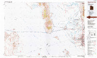
~ Promontory Point UT topo map, 1:100000 scale, 30 X 60 Minute, Historical, 1987, updated 1987
Promontory Point, Utah, USGS topographic map dated 1987.
Includes geographic coordinates (latitude and longitude). This topographic map is suitable for hiking, camping, and exploring, or framing it as a wall map.
Printed on-demand using high resolution imagery, on heavy weight and acid free paper, or alternatively on a variety of synthetic materials.
Topos available on paper, Waterproof, Poly, or Tyvek. Usually shipping rolled, unless combined with other folded maps in one order.
- Product Number: USGS-5463165
- Free digital map download (high-resolution, GeoPDF): Promontory Point, Utah (file size: 26 MB)
- Map Size: please refer to the dimensions of the GeoPDF map above
- Weight (paper map): ca. 55 grams
- Map Type: POD USGS Topographic Map
- Map Series: HTMC
- Map Verison: Historical
- Cell ID: 68196
- Scan ID: 251415
- Imprint Year: 1987
- Woodland Tint: Yes
- Aerial Photo Year: 1984
- Edit Year: 1987
- Datum: NAD27
- Map Projection: Universal Transverse Mercator
- Map published by United States Geological Survey
- Map Language: English
- Scanner Resolution: 600 dpi
- Map Cell Name: Promontory Point
- Grid size: 30 X 60 Minute
- Date on map: 1987
- Map Scale: 1:100000
- Geographical region: Utah, United States
Neighboring Maps:
All neighboring USGS topo maps are available for sale online at a variety of scales.
Spatial coverage:
Topo map Promontory Point, Utah, covers the geographical area associated the following places:
- Apple Estates - Fairmount Park - Suburban Heights - Thurgood Estates - Park West Estates - Saline - Nerva - Margretta - Thompson Gardens - Terry Dale - Maplewood Estates - Sunset Square - Sunray - Farr Number Two - Al Vi Village - Valley Park Estates - Roy Park Addition - Raymond Shupe Addition - Westridge - Jackson Orchards - Marilyn Acres - Farr West - Country Meadows - Arthur Jones Estate - Little Mountain - Deanetta - Marriott-Slaterville - Tanner - Holley and Whitney - Kingsville Junction - Kentwood Estates - Lazy L Estates - Foxglen - Villa Moritz - Valleywest - Enchanted Homes Addition - Elta Glen - Cottonwood Meadows - Valley West Estates Numbe Two - Chestnut Park - West Hills - Westmond Condominium - C C Ann Estates - Clearfield Heights - Loma Bonita - Eves Garden - Slaterville - Municipal Acres - Alpine Ranchettes Two - Wen Dale Park - Warren - Arsenal Villa - Mountair Park - Marriott - Lori Ann Estates - Lake View Ward - Newport Haven - Interwest Condominium Project Phase A - Frew Estates - Glade Nielsen - Bridgewood Manor Condominium - Town and Country Estates - Lewis Estates - Midland Square - El Centro Estates - Rosehill - Meadowlane - Sunrise Park - Roy - Roi-Dell - Lucin - Terrace View - He Flys - Holley Acres - Heritage Square - Christensen - Tresend - Sundial Park - Pheasant Run Estates - Golden West Villa - Carriage Lane Number Two - Valhalla Estates - New Hampton Manor - Vae View - Colonial Gardens Condominium - Harrisville Heights - Lakeview - Valley Green Estates - Fairmount Park Annex - Hills of Homes - Country Village - Hill Acres - Taylor - Cherry Hill - Willow Wood - Barton-Thompson - Kentwood Condominium - Evona - Smedley Acres - Barton
- Map Area ID: AREA41.541-113-112
- Northwest corner Lat/Long code: USGSNW41.5-113
- Northeast corner Lat/Long code: USGSNE41.5-112
- Southwest corner Lat/Long code: USGSSW41-113
- Southeast corner Lat/Long code: USGSSE41-112
- Northern map edge Latitude: 41.5
- Southern map edge Latitude: 41
- Western map edge Longitude: -113
- Eastern map edge Longitude: -112


