
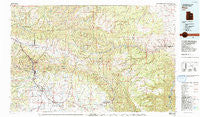
~ Price UT topo map, 1:100000 scale, 30 X 60 Minute, Historical, 1980, updated 1992
Price, Utah, USGS topographic map dated 1980.
Includes geographic coordinates (latitude and longitude). This topographic map is suitable for hiking, camping, and exploring, or framing it as a wall map.
Printed on-demand using high resolution imagery, on heavy weight and acid free paper, or alternatively on a variety of synthetic materials.
Topos available on paper, Waterproof, Poly, or Tyvek. Usually shipping rolled, unless combined with other folded maps in one order.
- Product Number: USGS-5463159
- Free digital map download (high-resolution, GeoPDF): Price, Utah (file size: 33 MB)
- Map Size: please refer to the dimensions of the GeoPDF map above
- Weight (paper map): ca. 55 grams
- Map Type: POD USGS Topographic Map
- Map Series: HTMC
- Map Verison: Historical
- Cell ID: 68192
- Scan ID: 251407
- Imprint Year: 1992
- Woodland Tint: Yes
- Aerial Photo Year: 1977
- Edit Year: 1980
- Datum: NAD27
- Map Projection: Universal Transverse Mercator
- Map published by United States Geological Survey
- Map Language: English
- Scanner Resolution: 600 dpi
- Map Cell Name: Price
- Grid size: 30 X 60 Minute
- Date on map: 1980
- Map Scale: 1:100000
- Geographical region: Utah, United States
Neighboring Maps:
All neighboring USGS topo maps are available for sale online at a variety of scales.
Spatial coverage:
Topo map Price, Utah, covers the geographical area associated the following places:
- Heiner - Sunnyside - Dragerton - Three Forks - Wellington - Wildcat - East Carbon City - Price - Upper Sunnyside - Columbia Junction - Martin - Standardville - Spring Glen - Kyune - Carbonville - Bruin Point - Helper - Royal - Wood Hill - Sunnyside Junction - Kenilworth - Sunnydale - Castle Gate (historical) - Peerless - Wattis Junction - Columbia - Storrs - Latuda
- Map Area ID: AREA4039.5-111-110
- Northwest corner Lat/Long code: USGSNW40-111
- Northeast corner Lat/Long code: USGSNE40-110
- Southwest corner Lat/Long code: USGSSW39.5-111
- Southeast corner Lat/Long code: USGSSE39.5-110
- Northern map edge Latitude: 40
- Southern map edge Latitude: 39.5
- Western map edge Longitude: -111
- Eastern map edge Longitude: -110


