
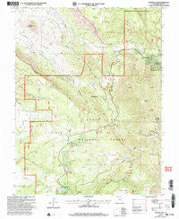
~ Warner Lake UT topo map, 1:24000 scale, 7.5 X 7.5 Minute, Historical, 2001, updated 2004
Warner Lake, Utah, USGS topographic map dated 2001.
Includes geographic coordinates (latitude and longitude). This topographic map is suitable for hiking, camping, and exploring, or framing it as a wall map.
Printed on-demand using high resolution imagery, on heavy weight and acid free paper, or alternatively on a variety of synthetic materials.
Topos available on paper, Waterproof, Poly, or Tyvek. Usually shipping rolled, unless combined with other folded maps in one order.
- Product Number: USGS-5461819
- Free digital map download (high-resolution, GeoPDF): Warner Lake, Utah (file size: 14 MB)
- Map Size: please refer to the dimensions of the GeoPDF map above
- Weight (paper map): ca. 55 grams
- Map Type: POD USGS Topographic Map
- Map Series: HTMC
- Map Verison: Historical
- Cell ID: 47494
- Scan ID: 252656
- Imprint Year: 2004
- Woodland Tint: Yes
- Aerial Photo Year: 1997
- Datum: NAD27
- Map Projection: Lambert Conformal Conic
- Map published by United States Geological Survey
- Map published by United States Forest Service
- Map Language: English
- Scanner Resolution: 600 dpi
- Map Cell Name: Warner Lake
- Grid size: 7.5 X 7.5 Minute
- Date on map: 2001
- Map Scale: 1:24000
- Geographical region: Utah, United States
Neighboring Maps:
All neighboring USGS topo maps are available for sale online at a variety of scales.
Spatial coverage:
Topo map Warner Lake, Utah, covers the geographical area associated the following places:
- Dry Fork Mill Creek - Horse Mountain - Gold Knob - Cold Spring - Maloy Park - South Mesa - Bald Mesa - Wet Fork Mill Creek - Castleton Cemetery - Mason Spring Creek - Jerry Stocks Mine - Castle Valley Overlook - Wilcox Flat - Cain Hollow - Harpole Mesa - Mason Draw - Porcupine Draw - Jimmy Keen Flat - Wilson Mesa - Warner Lake - Adobe Mesa - Boren Mesa - Warner Campground - Lake Oowah Dam - Spring Branch - Miners Basin - Shuman Gulch - Porcupine Ranch - Pinhook Valley - Warner Ranger Station - Oowah Campground - Castleton - Pinhook Creek - Pinhook Draw Historical Marker - Mesa Guard Station - Mill Creek Canyon Overlook - Webb Hollow Creek - Mason Spring - Round Mountain - Miners Basin - Grand View - Lake Oowah
- Map Area ID: AREA38.62538.5-109.375-109.25
- Northwest corner Lat/Long code: USGSNW38.625-109.375
- Northeast corner Lat/Long code: USGSNE38.625-109.25
- Southwest corner Lat/Long code: USGSSW38.5-109.375
- Southeast corner Lat/Long code: USGSSE38.5-109.25
- Northern map edge Latitude: 38.625
- Southern map edge Latitude: 38.5
- Western map edge Longitude: -109.375
- Eastern map edge Longitude: -109.25


