
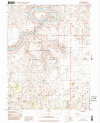
~ The Loop UT topo map, 1:24000 scale, 7.5 X 7.5 Minute, Historical, 1997, updated 2002
The Loop, Utah, USGS topographic map dated 1997.
Includes geographic coordinates (latitude and longitude). This topographic map is suitable for hiking, camping, and exploring, or framing it as a wall map.
Printed on-demand using high resolution imagery, on heavy weight and acid free paper, or alternatively on a variety of synthetic materials.
Topos available on paper, Waterproof, Poly, or Tyvek. Usually shipping rolled, unless combined with other folded maps in one order.
- Product Number: USGS-5461423
- Free digital map download (high-resolution, GeoPDF): The Loop, Utah (file size: 13 MB)
- Map Size: please refer to the dimensions of the GeoPDF map above
- Weight (paper map): ca. 55 grams
- Map Type: POD USGS Topographic Map
- Map Series: HTMC
- Map Verison: Historical
- Cell ID: 44746
- Scan ID: 252339
- Imprint Year: 2002
- Woodland Tint: Yes
- Photo Inspection Year: 1997
- Aerial Photo Year: 1981
- Datum: NAD27
- Map Projection: Transverse Mercator
- Provisional map: Yes
- Map published by United States Geological Survey
- Map Language: English
- Scanner Resolution: 600 dpi
- Map Cell Name: The Loop
- Grid size: 7.5 X 7.5 Minute
- Date on map: 1997
- Map Scale: 1:24000
- Geographical region: Utah, United States
Neighboring Maps:
All neighboring USGS topo maps are available for sale online at a variety of scales.
Spatial coverage:
Topo map The Loop, Utah, covers the geographical area associated the following places:
- Cave Spring - Twin Valleys - Devils Pocket - Devils Lane - The Needles Ranger Station - Squaw Butte - The Slide - Colorado River Overlook - Soda Spring - Squaw Spring - Devils Pocket - Lower Jump - Soda Spring - Wooden Shoe - Roadside Ruin - Silver Stairs - Squaw Flat Campground - Squaw Flat - Elephant Hill - Elephant Canyon - Canyonlands National Park Needles Fire District - Devils Canyon - Cyclone Canyon - The Loop - Little Spring Canyon - Salt Creek - Little Spring Canyon - Big Spring Canyon Overlook - Big Spring Canyon - Pothole Point - Lost Canyon - Cave Spring Trail - Twin Valleys
- Map Area ID: AREA38.2538.125-109.875-109.75
- Northwest corner Lat/Long code: USGSNW38.25-109.875
- Northeast corner Lat/Long code: USGSNE38.25-109.75
- Southwest corner Lat/Long code: USGSSW38.125-109.875
- Southeast corner Lat/Long code: USGSSE38.125-109.75
- Northern map edge Latitude: 38.25
- Southern map edge Latitude: 38.125
- Western map edge Longitude: -109.875
- Eastern map edge Longitude: -109.75


