
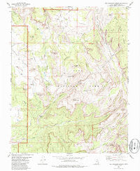
~ The Guardian Angels UT topo map, 1:24000 scale, 7.5 X 7.5 Minute, Historical, 1980, updated 1986
The Guardian Angels, Utah, USGS topographic map dated 1980.
Includes geographic coordinates (latitude and longitude). This topographic map is suitable for hiking, camping, and exploring, or framing it as a wall map.
Printed on-demand using high resolution imagery, on heavy weight and acid free paper, or alternatively on a variety of synthetic materials.
Topos available on paper, Waterproof, Poly, or Tyvek. Usually shipping rolled, unless combined with other folded maps in one order.
- Product Number: USGS-5461403
- Free digital map download (high-resolution, GeoPDF): The Guardian Angels, Utah (file size: 12 MB)
- Map Size: please refer to the dimensions of the GeoPDF map above
- Weight (paper map): ca. 55 grams
- Map Type: POD USGS Topographic Map
- Map Series: HTMC
- Map Verison: Historical
- Cell ID: 44729
- Scan ID: 252322
- Imprint Year: 1986
- Woodland Tint: Yes
- Aerial Photo Year: 1973
- Edit Year: 1980
- Field Check Year: 1974
- Datum: NAD27
- Map Projection: Lambert Conformal Conic
- Map published by United States Geological Survey
- Map Language: English
- Scanner Resolution: 600 dpi
- Map Cell Name: The Guardian Angels
- Grid size: 7.5 X 7.5 Minute
- Date on map: 1980
- Map Scale: 1:24000
- Geographical region: Utah, United States
Neighboring Maps:
All neighboring USGS topo maps are available for sale online at a variety of scales.
Spatial coverage:
Topo map The Guardian Angels, Utah, covers the geographical area associated the following places:
- Spendlove Knoll - North Guardian Angel - The Subway - Grapevine Spring - Right Fork North Creek - Northgate Peaks - Pine Valley Peak - Blue Creek - Sawmill Springs - The Bishopric - Lee Valley - Wolf Spring Wash - South Guardian Angel - Pine Valley - Midville Site - Oak Spring Valley - Ivins Mountain - Trail Canyon - Tabernacle Dome - Cave Valley - Grapevine Wash - Little Creek Sinks - Jobs Head - Zion National Park Post Office (historical) - Inclined Temple - Greatheart Mesa - Russell Gulch - Left Fork North Creek - Little Creek Valley - Wildcat Canyon - Lambs Knoll - Great West Canyon - Cave Knoll - Zion Wilderness - Wolf Springs Wash - Firepit Knoll - Pocket Mesa - Guardian Angel Pass - Little Creek - Double Falls - Zion National Park - Pine Spring Wash - Lava Point Trail
- Map Area ID: AREA37.37537.25-113.125-113
- Northwest corner Lat/Long code: USGSNW37.375-113.125
- Northeast corner Lat/Long code: USGSNE37.375-113
- Southwest corner Lat/Long code: USGSSW37.25-113.125
- Southeast corner Lat/Long code: USGSSE37.25-113
- Northern map edge Latitude: 37.375
- Southern map edge Latitude: 37.25
- Western map edge Longitude: -113.125
- Eastern map edge Longitude: -113


