
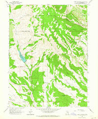
~ Tabby Mountain UT topo map, 1:24000 scale, 7.5 X 7.5 Minute, Historical, 1962, updated 1964
Tabby Mountain, Utah, USGS topographic map dated 1962.
Includes geographic coordinates (latitude and longitude). This topographic map is suitable for hiking, camping, and exploring, or framing it as a wall map.
Printed on-demand using high resolution imagery, on heavy weight and acid free paper, or alternatively on a variety of synthetic materials.
Topos available on paper, Waterproof, Poly, or Tyvek. Usually shipping rolled, unless combined with other folded maps in one order.
- Product Number: USGS-5461263
- Free digital map download (high-resolution, GeoPDF): Tabby Mountain, Utah (file size: 12 MB)
- Map Size: please refer to the dimensions of the GeoPDF map above
- Weight (paper map): ca. 55 grams
- Map Type: POD USGS Topographic Map
- Map Series: HTMC
- Map Verison: Historical
- Cell ID: 44128
- Scan ID: 252223
- Imprint Year: 1964
- Woodland Tint: Yes
- Aerial Photo Year: 1958
- Field Check Year: 1962
- Datum: NAD27
- Map Projection: Polyconic
- Map published by United States Geological Survey
- Map Language: English
- Scanner Resolution: 600 dpi
- Map Cell Name: Tabby Mountain
- Grid size: 7.5 X 7.5 Minute
- Date on map: 1962
- Map Scale: 1:24000
- Geographical region: Utah, United States
Neighboring Maps:
All neighboring USGS topo maps are available for sale online at a variety of scales.
Spatial coverage:
Topo map Tabby Mountain, Utah, covers the geographical area associated the following places:
- Red Creek Dam - Tabby Creek - Coyote Draw - Big Lake - Grey Wolf Mountain - Right Fork Grass Hollow - Little Bear Hollow - Kersha Creek - Little Lake - Mill Hollow - Rock Spring - Timber Canyon - Tabby Mountain - Birch Spring - Beer Spring - Seth Hollow - Kersha Bench - Rough Hollow - Thunder Ridge Airpark - Chuck Hollow - Rough Hollow - Right Fork Mill Hollow - Whiskey Spring - Santaquin Spring - Red Creek Reservoir - Red Creek Reservoir - Birch Spring
- Map Area ID: AREA40.37540.25-110.875-110.75
- Northwest corner Lat/Long code: USGSNW40.375-110.875
- Northeast corner Lat/Long code: USGSNE40.375-110.75
- Southwest corner Lat/Long code: USGSSW40.25-110.875
- Southeast corner Lat/Long code: USGSSE40.25-110.75
- Northern map edge Latitude: 40.375
- Southern map edge Latitude: 40.25
- Western map edge Longitude: -110.875
- Eastern map edge Longitude: -110.75


