
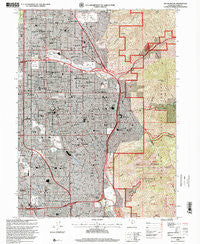
~ Sugar House UT topo map, 1:24000 scale, 7.5 X 7.5 Minute, Historical, 1998, updated 2001
Sugar House, Utah, USGS topographic map dated 1998.
Includes geographic coordinates (latitude and longitude). This topographic map is suitable for hiking, camping, and exploring, or framing it as a wall map.
Printed on-demand using high resolution imagery, on heavy weight and acid free paper, or alternatively on a variety of synthetic materials.
Topos available on paper, Waterproof, Poly, or Tyvek. Usually shipping rolled, unless combined with other folded maps in one order.
- Product Number: USGS-5461201
- Free digital map download (high-resolution, GeoPDF): Sugar House, Utah (file size: 25 MB)
- Map Size: please refer to the dimensions of the GeoPDF map above
- Weight (paper map): ca. 55 grams
- Map Type: POD USGS Topographic Map
- Map Series: HTMC
- Map Verison: Historical
- Cell ID: 43619
- Scan ID: 252183
- Imprint Year: 2001
- Woodland Tint: Yes
- Aerial Photo Year: 1997
- Datum: NAD27
- Map Projection: Lambert Conformal Conic
- Map published by United States Geological Survey
- Map published by United States Forest Service
- Map Language: English
- Scanner Resolution: 600 dpi
- Map Cell Name: Sugar House
- Grid size: 7.5 X 7.5 Minute
- Date on map: 1998
- Map Scale: 1:24000
- Geographical region: Utah, United States
Neighboring Maps:
All neighboring USGS topo maps are available for sale online at a variety of scales.
Spatial coverage:
Topo map Sugar House, Utah, covers the geographical area associated the following places:
- Sears Addition - Oakcrest - Broadbent - Westminster Heights - J and S Subdivision - Woodstock Village - Olympus Heights - Angie Circle Condominium - Holladay Haven Condominium - Ethel Gardens - Heather Circle - Spring Creek Manor - Spring Creek Estates - North Holladay - Spring Dale - Laura Park - Briarwood Hills - Akron - Cottonwood Park - Del Ann - Stev Linda - Sierra Dawn Condominium - Mervilla Condominium - Countryside Condominium - Casto Gardens - Terra Linda - Litson - Mount Olympus Acres - Cottonwood Meadows - Fairway Estates Condominium - Krista Condominium - Linden Circle - Green Meadows - Winder Meadows - Dover Hill Condominium - Brubaker Park - Three Fountains East Condominium - Highland Orchard Condominium - Westmoreland Place - Cottonwood Manor - Mar Vian - Holladay Village Condominium - Lakewood - Huffaker - Blue Spruce - Williams - Yalecroft - Villa Marie - Wren Lane West - Fontaine Bleu - Belle Meadows - East Holladay Condominium - Wells - Farley - Ridge Road - Maywood Hills - Normikemark Estates - Casto Pines Condominium - Spring Lane Condominium - Quailbrook East Condominium - Vista Village - Brookstone Condo - TGanglewood Condominium - Artistic Terrace - Johnsonville - Wander Village - Crus - Carsey Acres - Bellwood Acres - Dawn Circle - Tanner Lane Condo - Wayland Station at Old Farm Condo - Manor Estates - Majestic Heights - Easton in Holladay Condominium - Foothill - Oakdale - Holladay - Tall Oaks - Yale Gardens - C Barton Grover - Murray Park Cove - Standia - Rivendell Condominium - Hidden Village - Paradise Park - Win Del - Murray Condominium - Cottonwood - Jo Lynn - Holiday Center Addition - Adams Park - East Olympus Heights - Zions Park - Birch Point Condominium - Powell Circle - Knudsens Corner - Holladay Acres - Westminster Park - Wren Hollow
- Map Area ID: AREA40.7540.625-111.875-111.75
- Northwest corner Lat/Long code: USGSNW40.75-111.875
- Northeast corner Lat/Long code: USGSNE40.75-111.75
- Southwest corner Lat/Long code: USGSSW40.625-111.875
- Southeast corner Lat/Long code: USGSSE40.625-111.75
- Northern map edge Latitude: 40.75
- Southern map edge Latitude: 40.625
- Western map edge Longitude: -111.875
- Eastern map edge Longitude: -111.75


