
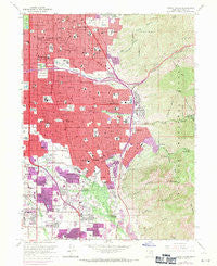
~ Sugar House UT topo map, 1:24000 scale, 7.5 X 7.5 Minute, Historical, 1963, updated 1971
Sugar House, Utah, USGS topographic map dated 1963.
Includes geographic coordinates (latitude and longitude). This topographic map is suitable for hiking, camping, and exploring, or framing it as a wall map.
Printed on-demand using high resolution imagery, on heavy weight and acid free paper, or alternatively on a variety of synthetic materials.
Topos available on paper, Waterproof, Poly, or Tyvek. Usually shipping rolled, unless combined with other folded maps in one order.
- Product Number: USGS-5461197
- Free digital map download (high-resolution, GeoPDF): Sugar House, Utah (file size: 17 MB)
- Map Size: please refer to the dimensions of the GeoPDF map above
- Weight (paper map): ca. 55 grams
- Map Type: POD USGS Topographic Map
- Map Series: HTMC
- Map Verison: Historical
- Cell ID: 43619
- Scan ID: 252180
- Imprint Year: 1971
- Woodland Tint: Yes
- Photo Revision Year: 1969
- Aerial Photo Year: 1969
- Field Check Year: 1963
- Datum: NAD27
- Map Projection: Polyconic
- Map published by United States Geological Survey
- Map Language: English
- Scanner Resolution: 600 dpi
- Map Cell Name: Sugar House
- Grid size: 7.5 X 7.5 Minute
- Date on map: 1963
- Map Scale: 1:24000
- Geographical region: Utah, United States
Neighboring Maps:
All neighboring USGS topo maps are available for sale online at a variety of scales.
Spatial coverage:
Topo map Sugar House, Utah, covers the geographical area associated the following places:
- Mar Vian - Sierra Dawn Condominium - Executive Suites of Fountain East - Yuma View - White Circle - Gill - Edinburgh of Holladay Condominium - Dover Hill Condominium - Sunrise Hills - Biscayne Park - Tidewater Village Condominium - Shady Brook Estates - Bay - Mount Olympus Hills - Belle Meadows - Apple Blossom Estate - Holladay Park - Helm - Briarwood Hills - Pine Mountain - Akron - Suncrest Park - Linden Circle - Old Colony - Farley - Sage Hill - Tanglewood Subdivision Number 3 - Ethel Gardens - Westminster Heights - Monte Cristo Condo - Cliffwood Park - Cottonwood Park - Westmoreland Place - Green Valley - Foothill Village - Fairbrook Condominium - Blackburn - Paradise Park - Green Meadows - Stev Linda - Quailbrook East Condominium - Holladay Meadows Condominium - Rose Garden - Dawn Circle - Highland Drive Park - Pine Hill - Holladay Acres - Fairview Gardens - Wells - Valley Fair Estates - Birch Point Condominium - Deerfield Condominium - Vine Street East Condominium - Mervilla Condominium - Enchanted Village - Wallace Lane Condominium - Cottonwood - Farnsworth Condominium - Cambridge Estates - Zions Park - Cottonwood Estates - Ranchfield - Phylden - Canyon Cove - Mount Olympus Gardens Condominium - Lincoln Manor Condominium - Johnsonville - Yale Heights - Wren Lane West - Country Garden Estates - Nathan Circle - East Cottonwood Heights - Castro Heoghts - Tall Oaks - Bellwood Acres - Standia - Brimley - Blue Grass Acres - Wasatch Village - Rosalie Heights - Briarcreek Condominium - Brubaker Park - Holladay - Three Fountains Townhomes and Manor Houses - Brentwood Park - Wellington Circle - Putnam Place - Parkcrest - Holladay Highlands - Holladay Circle - Shadowns - Holladay Villa Homes Condominium - Manuela - Walnut Brook - Sleepy Hollow - Waymark - Loredell - Mandalay Terrace - Florence Hollow - Howe
- Map Area ID: AREA40.7540.625-111.875-111.75
- Northwest corner Lat/Long code: USGSNW40.75-111.875
- Northeast corner Lat/Long code: USGSNE40.75-111.75
- Southwest corner Lat/Long code: USGSSW40.625-111.875
- Southeast corner Lat/Long code: USGSSE40.625-111.75
- Northern map edge Latitude: 40.75
- Southern map edge Latitude: 40.625
- Western map edge Longitude: -111.875
- Eastern map edge Longitude: -111.75


