
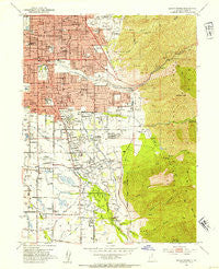
~ Sugar House UT topo map, 1:24000 scale, 7.5 X 7.5 Minute, Historical, 1952, updated 1954
Sugar House, Utah, USGS topographic map dated 1952.
Includes geographic coordinates (latitude and longitude). This topographic map is suitable for hiking, camping, and exploring, or framing it as a wall map.
Printed on-demand using high resolution imagery, on heavy weight and acid free paper, or alternatively on a variety of synthetic materials.
Topos available on paper, Waterproof, Poly, or Tyvek. Usually shipping rolled, unless combined with other folded maps in one order.
- Product Number: USGS-5461193
- Free digital map download (high-resolution, GeoPDF): Sugar House, Utah (file size: 17 MB)
- Map Size: please refer to the dimensions of the GeoPDF map above
- Weight (paper map): ca. 55 grams
- Map Type: POD USGS Topographic Map
- Map Series: HTMC
- Map Verison: Historical
- Cell ID: 43619
- Scan ID: 252178
- Imprint Year: 1954
- Woodland Tint: Yes
- Aerial Photo Year: 1950
- Field Check Year: 1952
- Survey Year: 1934
- Datum: NAD27
- Map Projection: Polyconic
- Map published by United States Geological Survey
- Map Language: English
- Scanner Resolution: 600 dpi
- Map Cell Name: Sugar House
- Grid size: 7.5 X 7.5 Minute
- Date on map: 1952
- Map Scale: 1:24000
- Geographical region: Utah, United States
Neighboring Maps:
All neighboring USGS topo maps are available for sale online at a variety of scales.
Spatial coverage:
Topo map Sugar House, Utah, covers the geographical area associated the following places:
- Shangrila - Edgewood Estates - Cove on Mount Olympus Place - Florence Hollow - Bonnie Brae - Tyler - Wren Circle Condominium - Holladay Edgehill - Del Ann - Nathan Circle - Southview - Valley Fair Estates - The Woodlands Business Park - Linden Circle - Wagstaff Acres - Pheasant Hollow - Canterbay Estates - Indian Wells - Viewmont Condominium - Waymark - Peony Gardens - Vine Street East Condominium - Wren Hollow - Forest Dale - Startup - Haven Place - Terraces Mount Olympus Condominium - Cliffwood Park - Bonnie View - East Meadows - Midland Court Condominium - Brentwood Park - Springtree Condominium - Manuela - Standia - Andlor - International Gardens - Wren Lane West - Highland Orchard Condominium - Shaleh Estates - Holladay Villa Homes Condominium - Westminster Heights - Holladay East - Oakwood Acres - Olympus Shadows Estates - Briarwood Estates - Shadowns - East Holladay Slopes - Rose Garden - Pine Hill - Adams Park - Country Corners Condominium - Cottonwood Meadows - Applewood - Chevy Chase - Mar Vian - Southwood Two - Holladay Meadows Condominium - Castro Heoghts - Brockwood - Sugar House - Yalecrest Heights - Olympus View - Cottonwood Manor - Maywood Hills - Holladay Highlands - Esquire Acres - Foothill - Farnsworth Condominium - Woodstock - Westmoreland Place - Belle Meadows - Waterbury Condominium - Holiday Center Addition - Cottonwood Grove Condominium - Angie Circle Condominium - Easton in Holladay Condominium - Donjean - Arbor Estates Condominium - Mountain View Orchard Heights - Clayton - Fairway Estates Condominium - Cottonwood Hills - Flamingo Hills - Rolling Knolls - Hillsden Addition - Zions Park - Holladay Creek Condominium - Spring Creek Estates - Mount Olympus Hills - Cambria Pines - Three Fountains Townhomes and Manor Houses - Raintree East - Tidewater Village Condominium - Cottonwood Acres - South Cottonwood Acres - Ute - Rosalie Heights - Holladay Highlands Three - North Holladay
- Map Area ID: AREA40.7540.625-111.875-111.75
- Northwest corner Lat/Long code: USGSNW40.75-111.875
- Northeast corner Lat/Long code: USGSNE40.75-111.75
- Southwest corner Lat/Long code: USGSSW40.625-111.875
- Southeast corner Lat/Long code: USGSSE40.625-111.75
- Northern map edge Latitude: 40.75
- Southern map edge Latitude: 40.625
- Western map edge Longitude: -111.875
- Eastern map edge Longitude: -111.75


