
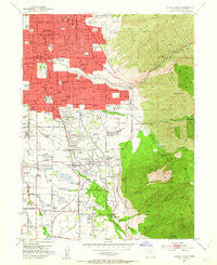
~ Sugar House UT topo map, 1:24000 scale, 7.5 X 7.5 Minute, Historical, 1952, updated 1954
Sugar House, Utah, USGS topographic map dated 1952.
Includes geographic coordinates (latitude and longitude). This topographic map is suitable for hiking, camping, and exploring, or framing it as a wall map.
Printed on-demand using high resolution imagery, on heavy weight and acid free paper, or alternatively on a variety of synthetic materials.
Topos available on paper, Waterproof, Poly, or Tyvek. Usually shipping rolled, unless combined with other folded maps in one order.
- Product Number: USGS-5461191
- Free digital map download (high-resolution, GeoPDF): Sugar House, Utah (file size: 15 MB)
- Map Size: please refer to the dimensions of the GeoPDF map above
- Weight (paper map): ca. 55 grams
- Map Type: POD USGS Topographic Map
- Map Series: HTMC
- Map Verison: Historical
- Cell ID: 43619
- Scan ID: 252177
- Imprint Year: 1954
- Woodland Tint: Yes
- Visual Version Number: 1
- Aerial Photo Year: 1950
- Field Check Year: 1952
- Survey Year: 1934
- Datum: NAD27
- Map Projection: Polyconic
- Map published by United States Geological Survey
- Map Language: English
- Scanner Resolution: 600 dpi
- Map Cell Name: Sugar House
- Grid size: 7.5 X 7.5 Minute
- Date on map: 1952
- Map Scale: 1:24000
- Geographical region: Utah, United States
Neighboring Maps:
All neighboring USGS topo maps are available for sale online at a variety of scales.
Spatial coverage:
Topo map Sugar House, Utah, covers the geographical area associated the following places:
- Williams - Tanglewood Subdivision Number 3 - Rustic Acres - Rolling Knolls - Locust Grove - Brookside Park - Brookwood - Pine Hill - Homestead Court - South Dale - Ranchfield - Knudsens Corner - Ute - Easton in Holladay Condominium - Dublin Town - Holladay Acres - Southview - Haven Grove - Carriage Lane Condominium - Cottonwood Meadows - Yale Gardens - Three Fountains Young American Family Condominium - Bellwood Acres - Creekside East Condominium - Kimberly Park - Mount Olympus Cove - Indian Wells - Ewell - Tara Gardens Condominium - Country Corners Condominium - Yale Heights - Rivendell Condominium - Aix La Chapelle Condominium - Hillsden Addition - Smithfield - Cove on Mount Olympus Place - Briarcreek Condominium - Shady Grove - Bron Breck - Arbor Estates Condominium - Southwood Three and Four - Blue Spruce Heights - Woodbridge Condominium - White Hill Estates - Lake Pines Apartment Condominium - Fors - Sierra Dawn Condominium - Southwood - Holladay Gardens - Murray Condominium - Johnsonville - Prowswood Plaza Condominium - Holiday Center Addition - Rothmoor Estates - Blue Spruce - Arcadia Park Condominium - Pheasant Hollow - Kellgreen Acres - Broadbent - Manor Estates - Nielson - Brookstone Condo - Mount Athena Condominium - Spring Lane Condominium - Hamilton Village - Springtree Condominium - Peony Gardens - Three Fountains Manor House Condominium - White Circle - Sleepy Hollow Two - Walnut Brook - Wagstaff Acres - Cambria Pines - Win Del - Yalecrest Park - Shady Brook Estates - Vista Village - Highland Orchard Condominium - Ridge Road - Mount Olympus - East Holladay Condominium - Juniper - Fontaine Bleu - Lazy Bar - Yalecrest Heights - Adams Park - Mar Vian - East Olympus Heights - Holladay Pines Condominium - Stev Linda - Tanner Lane Condo - Blackburn - Cottonwood Ridge - Fawn Gardens - Canyon Rim - Wasatch Village - Phylden - Woodstock Village - Old Colony - Yuma View
- Map Area ID: AREA40.7540.625-111.875-111.75
- Northwest corner Lat/Long code: USGSNW40.75-111.875
- Northeast corner Lat/Long code: USGSNE40.75-111.75
- Southwest corner Lat/Long code: USGSSW40.625-111.875
- Southeast corner Lat/Long code: USGSSE40.625-111.75
- Northern map edge Latitude: 40.75
- Southern map edge Latitude: 40.625
- Western map edge Longitude: -111.875
- Eastern map edge Longitude: -111.75


