
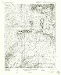
~ Springdale SE UT topo map, 1:24000 scale, 7.5 X 7.5 Minute, Historical, 1956, updated 1956
Springdale SE, Utah, USGS topographic map dated 1956.
Includes geographic coordinates (latitude and longitude). This topographic map is suitable for hiking, camping, and exploring, or framing it as a wall map.
Printed on-demand using high resolution imagery, on heavy weight and acid free paper, or alternatively on a variety of synthetic materials.
Topos available on paper, Waterproof, Poly, or Tyvek. Usually shipping rolled, unless combined with other folded maps in one order.
- Product Number: USGS-5460993
- Free digital map download (high-resolution, GeoPDF): Springdale SE, Utah (file size: 10 MB)
- Map Size: please refer to the dimensions of the GeoPDF map above
- Weight (paper map): ca. 55 grams
- Map Type: POD USGS Topographic Map
- Map Series: HTMC
- Map Verison: Historical
- Cell ID: 13900
- Scan ID: 252029
- Imprint Year: 1956
- Aerial Photo Year: 1953
- Datum: Unstated
- Map Projection: Unstated
- Map published by United States Geological Survey
- Keywords: Nonstandard Press Run
- Map Language: English
- Scanner Resolution: 600 dpi
- Map Cell Name: Elephant Butte
- Grid size: 7.5 X 7.5 Minute
- Date on map: 1956
- Map Scale: 1:24000
- Geographical region: Utah, United States
Neighboring Maps:
All neighboring USGS topo maps are available for sale online at a variety of scales.
Spatial coverage:
Topo map Springdale SE, Utah, covers the geographical area associated the following places:
- Block Mesas - Elephant Gap - Oak Flat - Esplin Spring - Elephant Butte - Shunesburg Mail Trail - Moccasin Mountains - Wyatt Spring - Langston Willow Spring - Pine Spring - Sandstone Butte - Hise-Willow Spring - Dixie Knoll - Rosy Canyon - Kane Spring - Harris Flat - Harris Mountain - Kane Spring - Harris Point
- Map Area ID: AREA37.12537-112.875-112.75
- Northwest corner Lat/Long code: USGSNW37.125-112.875
- Northeast corner Lat/Long code: USGSNE37.125-112.75
- Southwest corner Lat/Long code: USGSSW37-112.875
- Southeast corner Lat/Long code: USGSSE37-112.75
- Northern map edge Latitude: 37.125
- Southern map edge Latitude: 37
- Western map edge Longitude: -112.875
- Eastern map edge Longitude: -112.75


