
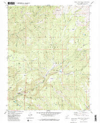
~ Shelly Baldy Peak UT topo map, 1:24000 scale, 7.5 X 7.5 Minute, Historical, 1981, updated 1981
Shelly Baldy Peak, Utah, USGS topographic map dated 1981.
Includes geographic coordinates (latitude and longitude). This topographic map is suitable for hiking, camping, and exploring, or framing it as a wall map.
Printed on-demand using high resolution imagery, on heavy weight and acid free paper, or alternatively on a variety of synthetic materials.
Topos available on paper, Waterproof, Poly, or Tyvek. Usually shipping rolled, unless combined with other folded maps in one order.
- Product Number: USGS-5460711
- Free digital map download (high-resolution, GeoPDF): Shelly Baldy Peak, Utah (file size: 15 MB)
- Map Size: please refer to the dimensions of the GeoPDF map above
- Weight (paper map): ca. 55 grams
- Map Type: POD USGS Topographic Map
- Map Series: HTMC
- Map Verison: Historical
- Cell ID: 40981
- Scan ID: 251844
- Imprint Year: 1981
- Woodland Tint: Yes
- Visual Version Number: 1
- Aerial Photo Year: 1973
- Edit Year: 1981
- Field Check Year: 1975
- Datum: NAD27
- Map Projection: Lambert Conformal Conic
- Map published by United States Geological Survey
- Map Language: English
- Scanner Resolution: 600 dpi
- Map Cell Name: Shelly Baldy Peak
- Grid size: 7.5 X 7.5 Minute
- Date on map: 1981
- Map Scale: 1:24000
- Geographical region: Utah, United States
Neighboring Maps:
All neighboring USGS topo maps are available for sale online at a variety of scales.
Spatial coverage:
Topo map Shelly Baldy Peak, Utah, covers the geographical area associated the following places:
- Hy Hunt Creek - Lousy Jim Creek - Gill Creek - Little Reservoir Dam - Beetle Creek - Copes Basin - Gunsight Flat - Bosman Creek - Three Creeks - Twin Lakes - Round Flat - Little Reservoir - Hi Hunt Creek - Buck Ridge - Harmony Park - Mount Holly Fire Statioin - Mud Flat - Duncan Creek - Van Fleet Hollow - Shelly Baldy Creek - Briggs Creek - Three Creeks Reservoir - Griffith Creek - Wilson Creek - Three Creeks Dam - Crazy Creek - Grizzly Ridges - Little Reservoir Campground - Sawmill Fork - Power Plant Number 2 - Sweetwater Creek - Shelly Baldy Peak - Mahogany Cove Campground - Third Spring Hollow - Lion Creek - Cys Cache - Briggs Ridge - Mount Holly Ski Area - Delano Ranger Station - Sage Hill Spring - South Fork Beaver River - Cougar Creek - Merchant Creek - Poison Creek - Hi Low Lake - Tushar Ridge - Baldwin Ridge - Iron Creek - Forked Flat - Manhard Creek - Straight Creek - Dry Hollow - West Fork Merchant Creek - Iant Ridge - Big John Flat - Tungsten Hollow - Kays Meadow - Lake Stream - Tushar Mountains - Robbers Roost - Britts Meadows - LeBaron Creek - Allred Spring - Peterson Flat - Gorrilla Creek - Bosman Ridge - North Fork Three Creeks - Waterfull Creek - Sawmill Ridge - Deer Creek - Iant Creek - Strawberry Flat - South Fork Three Creeks - Big Cove
- Map Area ID: AREA38.37538.25-112.5-112.375
- Northwest corner Lat/Long code: USGSNW38.375-112.5
- Northeast corner Lat/Long code: USGSNE38.375-112.375
- Southwest corner Lat/Long code: USGSSW38.25-112.5
- Southeast corner Lat/Long code: USGSSE38.25-112.375
- Northern map edge Latitude: 38.375
- Southern map edge Latitude: 38.25
- Western map edge Longitude: -112.5
- Eastern map edge Longitude: -112.375


