
~ Salt Lake City North UT topo map, 1:24000 scale, 7.5 X 7.5 Minute, Historical, 1963, updated 1971
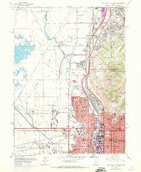
Salt Lake City North, Utah, USGS topographic map dated 1963.
Includes geographic coordinates (latitude and longitude). This topographic map is suitable for hiking, camping, and exploring, or framing it as a wall map.
Printed on-demand using high resolution imagery, on heavy weight and acid free paper, or alternatively on a variety of synthetic materials.
Topos available on paper, Waterproof, Poly, or Tyvek. Usually shipping rolled, unless combined with other folded maps in one order.
- Product Number: USGS-5460499
- Free digital map download (high-resolution, GeoPDF): Salt Lake City North, Utah (file size: 13 MB)
- Map Size: please refer to the dimensions of the GeoPDF map above
- Weight (paper map): ca. 55 grams
- Map Type: POD USGS Topographic Map
- Map Series: HTMC
- Map Verison: Historical
- Cell ID: 71500
- Scan ID: 251649
- Imprint Year: 1971
- Woodland Tint: Yes
- Photo Revision Year: 1969
- Aerial Photo Year: 1969
- Field Check Year: 1963
- Survey Year: 1951
- Datum: NAD27
- Map Projection: Polyconic
- Map published by United States Geological Survey
- Map Language: English
- Scanner Resolution: 600 dpi
- Map Cell Name: Salt Lake City North
- Grid size: 7.5 X 7.5 Minute
- Date on map: 1963
- Map Scale: 1:24000
- Geographical region: Utah, United States
Neighboring Maps:
All neighboring USGS topo maps are available for sale online at a variety of scales.
Spatial coverage:
Topo map Salt Lake City North, Utah, covers the geographical area associated the following places:
- Becks - Deskys Addition Three and Four - The Villa Granade Condominium - Plum Tree Condominium - Normandy Park - Wilkes - Wildwood - Empire Addition - Mountains Meadows - Sorrento Estates - Kabis and Myers - Westpointe - Briarwood Acres - Pacific Grove - Ingersoll Addition - Poplar Place - Talisman Drive - Ballard Avenues - Kimball Condominium - Bountiful Acres - Sundown - Willow Place - Villa - Paul - Bunnells - Cummings - Oakley - Meadow Crossing - Fritsch and Zulchs Addition - Odell Acres - South Valley View - Byers and Tolles Addition - McIntyre Building Condominium - Jackson Park Village - Morton Meadows - Val Verda - Kinney and Gourlays Improved City Plat - Avondale - Bountiful Townhouses - Valley Side - Garden Towers Condominium - Gateway Condominium - Western - Superior - Newport Heights Condominium - Park Rose - Geurts - Kelsey and Gillespie - Alda Verda - North Temple Street - Tara Condominium - City Crest Condominium - Trevi Towers Condominium - Deseret - Orchard Acres - North Canyon Heights - Martins - Deskys Addition Five - Jordan Place - Airport East Business Park - Tower Hill Condominium - Menlove Estates - Orchard Place - North Crest Park Condominium - Orson Ellis - New Rose Park - Brown Stone Condominium - Brown - Colorado - Garden Grove - Valley Side Circle - Kimballs - Lakeview Park - Doles Addition - Mountain Aire - Co Rae - Maryan Estates - Salt Lake City - Capitol Heights Condominium - South View - Shamrock Drive - Jones - Chalet - Catherine Circle - Hillside Townhouse Condominium - University - Sconberg - Rose Park - Hanson - Ensign Downs - Val Vista - Panorama Apartments Condominium - Capitol View - Woodland Gardens - Linda Loma Acres - Jenkins Orchard - Amos Addition - Hall Acres - LPT Condominium - Spring Meadow
- Map Area ID: AREA40.87540.75-112-111.875
- Northwest corner Lat/Long code: USGSNW40.875-112
- Northeast corner Lat/Long code: USGSNE40.875-111.875
- Southwest corner Lat/Long code: USGSSW40.75-112
- Southeast corner Lat/Long code: USGSSE40.75-111.875
- Northern map edge Latitude: 40.875
- Southern map edge Latitude: 40.75
- Western map edge Longitude: -112
- Eastern map edge Longitude: -111.875


