
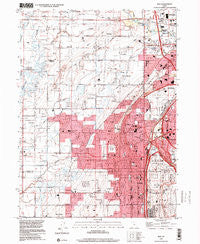
~ Roy UT topo map, 1:24000 scale, 7.5 X 7.5 Minute, Historical, 1999, updated 2001
Roy, Utah, USGS topographic map dated 1999.
Includes geographic coordinates (latitude and longitude). This topographic map is suitable for hiking, camping, and exploring, or framing it as a wall map.
Printed on-demand using high resolution imagery, on heavy weight and acid free paper, or alternatively on a variety of synthetic materials.
Topos available on paper, Waterproof, Poly, or Tyvek. Usually shipping rolled, unless combined with other folded maps in one order.
- Product Number: USGS-5460429
- Free digital map download (high-resolution, GeoPDF): Roy, Utah (file size: 13 MB)
- Map Size: please refer to the dimensions of the GeoPDF map above
- Weight (paper map): ca. 55 grams
- Map Type: POD USGS Topographic Map
- Map Series: HTMC
- Map Verison: Historical
- Cell ID: 38825
- Scan ID: 251596
- Imprint Year: 2001
- Woodland Tint: Yes
- Aerial Photo Year: 1997
- Datum: NAD83
- Map Projection: Universal Transverse Mercator
- Map published by United States Geological Survey
- Map Language: English
- Scanner Resolution: 600 dpi
- Map Cell Name: Roy
- Grid size: 7.5 X 7.5 Minute
- Date on map: 1999
- Map Scale: 1:24000
- Geographical region: Utah, United States
Neighboring Maps:
All neighboring USGS topo maps are available for sale online at a variety of scales.
Spatial coverage:
Topo map Roy, Utah, covers the geographical area associated the following places:
- Holley and Whitney - Royset Park Addition and Annex - Bonham - Hooper - Sunray - Parks - Country Lane - Rosewood Manor Condominium - Goodfellow - Lee Mesa - New Hampton Manor - Meadowlane - Alpine Ranchettes - Tullis Addition - Commonwealth Square - Roskelley - North Crest Manor - Western Willows Cluster - Sun - Vern G Taylor - Kentwood Condominium - Pleasant View - William R Patterson - Fowers - Interwest Condominium Project Phase A - Terry Estates - Raymond Shupe Addition - Tri-S Village Estates - West Haven - Mel Stephenson - Garden Acres - Enchanted Homes Addition - Lazy L Estates - Country Estates Park - Arthur Jones Estate - Maplewood Estates - Clint Village - Herefordshire - The Parsons Place - Purser - DeGiorgio - Chateau-Park Condominium - Valley View Acres - Lucin - Maybrook - Carriage Place - Morby Park - Berrett - Arsenal Villa - Barton - Pinto Acres - Heather Heights - Roy - Midland Farms - Foxglen - Kentwood Estates - Pony Acres Estates - Lincoln Court Condominium - Herefordshire Condominium - Buena Vista - Roy West - Arsenal - John Fuit - Lakeside Park - Midland Square - Apple Valley Estates - Draayer - Roi-Dell - Lewis Estates - Hy-Mesa - Lori Ann Estates - West View Park - Kingsville Junction - Hatch - Municipal Acres - Riverdale - Scotts Dale - Heritage Square - Loma Bonita - Sunset - Shamrock - Clays Ranchettes - Sandridge Estates - Gilene - Ridgewood Estates - Relico - Pony Acres Estates - Harveys Redwood Estates - Valley Side - Coy - Rosewood Estates - Sunset Dale - Sundown Estates - Page Estates - Brownscott Manor - Olivewood Park - Tanner - Bel Air - Roy Park Addition - Rich Acres
- Map Area ID: AREA41.2541.125-112.125-112
- Northwest corner Lat/Long code: USGSNW41.25-112.125
- Northeast corner Lat/Long code: USGSNE41.25-112
- Southwest corner Lat/Long code: USGSSW41.125-112.125
- Southeast corner Lat/Long code: USGSSE41.125-112
- Northern map edge Latitude: 41.25
- Southern map edge Latitude: 41.125
- Western map edge Longitude: -112.125
- Eastern map edge Longitude: -112


