
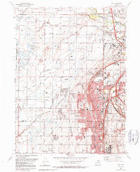
~ Roy UT topo map, 1:24000 scale, 7.5 X 7.5 Minute, Historical, 1990, updated 1990
Roy, Utah, USGS topographic map dated 1990.
Includes geographic coordinates (latitude and longitude). This topographic map is suitable for hiking, camping, and exploring, or framing it as a wall map.
Printed on-demand using high resolution imagery, on heavy weight and acid free paper, or alternatively on a variety of synthetic materials.
Topos available on paper, Waterproof, Poly, or Tyvek. Usually shipping rolled, unless combined with other folded maps in one order.
- Product Number: USGS-5460427
- Free digital map download (high-resolution, GeoPDF): Roy, Utah (file size: 13 MB)
- Map Size: please refer to the dimensions of the GeoPDF map above
- Weight (paper map): ca. 55 grams
- Map Type: POD USGS Topographic Map
- Map Series: HTMC
- Map Verison: Historical
- Cell ID: 38825
- Scan ID: 251595
- Imprint Year: 1990
- Woodland Tint: Yes
- Visual Version Number: 2
- Aerial Photo Year: 1986
- Edit Year: 1990
- Field Check Year: 1987
- Survey Year: 1955
- Datum: NAD27
- Map Projection: Lambert Conformal Conic
- Map published by United States Geological Survey
- Map Language: English
- Scanner Resolution: 600 dpi
- Map Cell Name: Roy
- Grid size: 7.5 X 7.5 Minute
- Date on map: 1990
- Map Scale: 1:24000
- Geographical region: Utah, United States
Neighboring Maps:
All neighboring USGS topo maps are available for sale online at a variety of scales.
Spatial coverage:
Topo map Roy, Utah, covers the geographical area associated the following places:
- Lawndale Addition - Montrose Park - Municipal Park - Colonial Gardens Condominium - Harveys Redwood Estates - West Haven - Quail Point - Arsenal - Clinton - Sunray - Murdock - Lakeview Equestrian Park - Linda Vista - Northpoint Condominium - Lincoln Court Condominium - Cozydale - Sunset - Graig Dale - Rosewood Manor Condominium - Elta Glen - Mountair Park - William R Patterson - Valleywest - Hal-Vern Park Addition - Eves Garden - Draayer - Fuit - Apple Estates - Lakeside Acres - Laurel Lea - Lavell - Christensen - Midland Square - Valley Side - Kingsville Junction - Fowers - Pheasant Run Estates - Lucin - Jackson Orchards - Bonham - Peppermint Park - Pleasant View - Marriott - Cedar Ridge Number Tow - Roi-Dell - Apple Park - Kanesville - C C Ann Estates - Jill - Barton - Valley View Acres - Swan Creek Estates - Donita - Taylor - Western Willows Cluster - He Flys - Bay View Park - Sandridge Estates - Clays Ranchettes - Herefordshire Condominium - Olivewood Park - Meadowlane - Deanetta - Pony Acres Estates - Bel Air - Marianne Condominium - Hooper - Tri-S Village Estates - Parkside - Roy West - Lori Ann Estates - North Crest Manor - Park Lake - Hatch - Roy - Lakeside Park - Coy - Parker - Diamond Hills - Raymond Shupe Addition - Cottonwood Meadows - The Parsons Place - Wilson - Westlake Village - Golden West Villa - Valley Park Estates - Municipal Acres - Cedar Ridge - West View Park - Roy Park Addition - Relico - Hy-Mesa - Anderson West Acres - Apple Valley Estates - Terry Dale - Sandalwood Square - Willow Wood - John Fuit - Rosewood Estates - Alpine Ranchettes Two
- Map Area ID: AREA41.2541.125-112.125-112
- Northwest corner Lat/Long code: USGSNW41.25-112.125
- Northeast corner Lat/Long code: USGSNE41.25-112
- Southwest corner Lat/Long code: USGSSW41.125-112.125
- Southeast corner Lat/Long code: USGSSE41.125-112
- Northern map edge Latitude: 41.25
- Southern map edge Latitude: 41.125
- Western map edge Longitude: -112.125
- Eastern map edge Longitude: -112


