
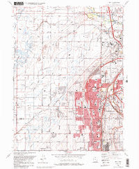
~ Roy UT topo map, 1:24000 scale, 7.5 X 7.5 Minute, Historical, 1990, updated 1990
Roy, Utah, USGS topographic map dated 1990.
Includes geographic coordinates (latitude and longitude). This topographic map is suitable for hiking, camping, and exploring, or framing it as a wall map.
Printed on-demand using high resolution imagery, on heavy weight and acid free paper, or alternatively on a variety of synthetic materials.
Topos available on paper, Waterproof, Poly, or Tyvek. Usually shipping rolled, unless combined with other folded maps in one order.
- Product Number: USGS-5460425
- Free digital map download (high-resolution, GeoPDF): Roy, Utah (file size: 13 MB)
- Map Size: please refer to the dimensions of the GeoPDF map above
- Weight (paper map): ca. 55 grams
- Map Type: POD USGS Topographic Map
- Map Series: HTMC
- Map Verison: Historical
- Cell ID: 38825
- Scan ID: 251594
- Imprint Year: 1990
- Woodland Tint: Yes
- Visual Version Number: 1
- Aerial Photo Year: 1986
- Edit Year: 1990
- Field Check Year: 1987
- Survey Year: 1955
- Datum: NAD27
- Map Projection: Lambert Conformal Conic
- Map published by United States Geological Survey
- Map Language: English
- Scanner Resolution: 600 dpi
- Map Cell Name: Roy
- Grid size: 7.5 X 7.5 Minute
- Date on map: 1990
- Map Scale: 1:24000
- Geographical region: Utah, United States
Neighboring Maps:
All neighboring USGS topo maps are available for sale online at a variety of scales.
Spatial coverage:
Topo map Roy, Utah, covers the geographical area associated the following places:
- Lakeside Park - Barton - Celeste Place Townhouses - Aland of Honey - Lewis Estates - New Hampton Manor - Sundown Estates - Sunset Dale - Westridge - Margretta - Sunset - Town and Country Estates - Harmony Park - Valleywest - Lakeside Acres - Page Estates - Lazy L Estates - Fuit - Hooper - Wen Dale Park - Eves Garden - Municipal Acres - Rosewood Manor Condominium - Val-Jo - Buena Vista - Meadowlane - Sunrise Park - Midland Farms - Hill Acres - Swan Creek Estates - Fairway Estates - Valley Park Estates - Muir Meadows - Mitchell Estates - Sandalwood Square - Westbrook - Brownscott Manor - Sunset Square - Shannondoah Estates - Clinton - Arthur Jones Estate - Fawcett - Anderson West Acres - West Haven - Roy West - Pony Acres Estates - West View Park - Allred - Wilson - Diamond Hills - Commonwealth Square - Mansion Heights Addition - Rich Acres - Garden Acres - Country Meadows - Ogden Heights - Relico - Jill - Montrose Park - Scotts Dale - White - Peterson - Willow Wood - Maybrook - Golden West Villa - Ridgewood Estates - Kentwood Estates - Valley Side - Morby Park - Cedar Ridge Number Tow - Marianne Condominium - Burmont Park - Crest View Acres - Glade-Nelson - Roi-Dell - Alpine Ranchettes Two - Holley and Whitney - Bay View Park - Valley Green Estates - Harveys Redwood Estates - Purser - Commonwealth Square Condominium - Kingsville Junction - Carriage Place - Apple Park - Richton Ranchettes - Donita - Graig Dale - Deanetta - Sherwood Oaks Condominium - Parker - Draayer - Marvins - Murdock - English Manor - John Fuit - Lakeview Gardens - Arsenal - La Loma - Taylor
- Map Area ID: AREA41.2541.125-112.125-112
- Northwest corner Lat/Long code: USGSNW41.25-112.125
- Northeast corner Lat/Long code: USGSNE41.25-112
- Southwest corner Lat/Long code: USGSSW41.125-112.125
- Southeast corner Lat/Long code: USGSSE41.125-112
- Northern map edge Latitude: 41.25
- Southern map edge Latitude: 41.125
- Western map edge Longitude: -112.125
- Eastern map edge Longitude: -112


