
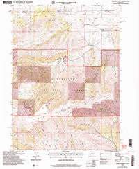
~ Rosevere Point UT topo map, 1:24000 scale, 7.5 X 7.5 Minute, Historical, 2001, updated 2006
Rosevere Point, Utah, USGS topographic map dated 2001.
Includes geographic coordinates (latitude and longitude). This topographic map is suitable for hiking, camping, and exploring, or framing it as a wall map.
Printed on-demand using high resolution imagery, on heavy weight and acid free paper, or alternatively on a variety of synthetic materials.
Topos available on paper, Waterproof, Poly, or Tyvek. Usually shipping rolled, unless combined with other folded maps in one order.
- Product Number: USGS-5460403
- Free digital map download (high-resolution, GeoPDF): Rosevere Point, Utah (file size: 17 MB)
- Map Size: please refer to the dimensions of the GeoPDF map above
- Weight (paper map): ca. 55 grams
- Map Type: POD USGS Topographic Map
- Map Series: HTMC
- Map Verison: Historical
- Cell ID: 72519
- Scan ID: 251583
- Imprint Year: 2006
- Woodland Tint: Yes
- Aerial Photo Year: 1998
- Edit Year: 2001
- Datum: NAD83
- Map Projection: Universal Transverse Mercator
- Map published by United States Geological Survey
- Map published by United States Forest Service
- Map Language: English
- Scanner Resolution: 600 dpi
- Map Cell Name: Rosevere Point
- Grid size: 7.5 X 7.5 Minute
- Date on map: 2001
- Map Scale: 1:24000
- Geographical region: Utah, United States
Neighboring Maps:
All neighboring USGS topo maps are available for sale online at a variety of scales.
Spatial coverage:
Topo map Rosevere Point, Utah, covers the geographical area associated the following places:
- Bull Lake - Clear Creek Cemetery - Rosevere Fork - Lake Fork - Rosevere Point - North Fork Indian Creek - Hidden Spring - Birch Spring - Right Fork Clear Creek - Big Spring - Birch Spring - Right Fork Clear Creek - Pinnacle - Water Canyon - Bull Canyon - Jim Canyon - Clear Creek Campground - Hidden Spring - Clear Creek - Bull Flat - Clear Creek Campground - Italian Canyon
- Map Area ID: AREA4241.875-113.375-113.25
- Northwest corner Lat/Long code: USGSNW42-113.375
- Northeast corner Lat/Long code: USGSNE42-113.25
- Southwest corner Lat/Long code: USGSSW41.875-113.375
- Southeast corner Lat/Long code: USGSSE41.875-113.25
- Northern map edge Latitude: 42
- Southern map edge Latitude: 41.875
- Western map edge Longitude: -113.375
- Eastern map edge Longitude: -113.25


