
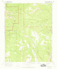
~ Rainbow Point UT topo map, 1:24000 scale, 7.5 X 7.5 Minute, Historical, 1966, updated 1969
Rainbow Point, Utah, USGS topographic map dated 1966.
Includes geographic coordinates (latitude and longitude). This topographic map is suitable for hiking, camping, and exploring, or framing it as a wall map.
Printed on-demand using high resolution imagery, on heavy weight and acid free paper, or alternatively on a variety of synthetic materials.
Topos available on paper, Waterproof, Poly, or Tyvek. Usually shipping rolled, unless combined with other folded maps in one order.
- Product Number: USGS-5460201
- Free digital map download (high-resolution, GeoPDF): Rainbow Point, Utah (file size: 9 MB)
- Map Size: please refer to the dimensions of the GeoPDF map above
- Weight (paper map): ca. 55 grams
- Map Type: POD USGS Topographic Map
- Map Series: HTMC
- Map Verison: Historical
- Cell ID: 36929
- Scan ID: 251443
- Imprint Year: 1969
- Woodland Tint: Yes
- Aerial Photo Year: 1963
- Field Check Year: 1966
- Datum: NAD27
- Map Projection: Polyconic
- Map published by United States Geological Survey
- Map Language: English
- Scanner Resolution: 600 dpi
- Map Cell Name: Rainbow Point
- Grid size: 7.5 X 7.5 Minute
- Date on map: 1966
- Map Scale: 1:24000
- Geographical region: Utah, United States
Neighboring Maps:
All neighboring USGS topo maps are available for sale online at a variety of scales.
Spatial coverage:
Topo map Rainbow Point, Utah, covers the geographical area associated the following places:
- Crawford Canyon - Riggs Spring Loop Trail - Rainbow Point - Yovimpa Point - Lower Crawford Creek - Pine Spring - Papoose Creek - Iron Spring - Birch Spring - South Fork Black Birch Canyon - Squaw Creek - The Promontory - Yovimpa Point Overlook - Ponderosa Ridge - Bullrush Hollow - Horse Mountain - Lonely Park - Corral Hollow - Riggs Spring - Twin Hills - Tank Canyon - Bristlecone Loop Trail - North Fork Black Birch Canyon - Dry Valley - Squaw Bench - Bullberry Spring - Swallow Park Ranch - Mutton Hollow - Horse Hollow - Lonely Spring - Rainbow Point Overlook
- Map Area ID: AREA37.537.375-112.25-112.125
- Northwest corner Lat/Long code: USGSNW37.5-112.25
- Northeast corner Lat/Long code: USGSNE37.5-112.125
- Southwest corner Lat/Long code: USGSSW37.375-112.25
- Southeast corner Lat/Long code: USGSSE37.375-112.125
- Northern map edge Latitude: 37.5
- Southern map edge Latitude: 37.375
- Western map edge Longitude: -112.25
- Eastern map edge Longitude: -112.125


