
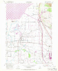
~ Plain City UT topo map, 1:24000 scale, 7.5 X 7.5 Minute, Historical, 1969, updated 1971
Plain City, Utah, USGS topographic map dated 1969.
Includes geographic coordinates (latitude and longitude). This topographic map is suitable for hiking, camping, and exploring, or framing it as a wall map.
Printed on-demand using high resolution imagery, on heavy weight and acid free paper, or alternatively on a variety of synthetic materials.
Topos available on paper, Waterproof, Poly, or Tyvek. Usually shipping rolled, unless combined with other folded maps in one order.
- Product Number: USGS-5460053
- Free digital map download (high-resolution, GeoPDF): Plain City, Utah (file size: 11 MB)
- Map Size: please refer to the dimensions of the GeoPDF map above
- Weight (paper map): ca. 55 grams
- Map Type: POD USGS Topographic Map
- Map Series: HTMC
- Map Verison: Historical
- Cell ID: 35519
- Scan ID: 251331
- Imprint Year: 1971
- Woodland Tint: Yes
- Photo Revision Year: 1969
- Aerial Photo Year: 1969
- Field Check Year: 1955
- Survey Year: 1926
- Datum: NAD27
- Map Projection: Polyconic
- Map published by United States Geological Survey
- Map published by United States Army Corps of Engineers
- Map Language: English
- Scanner Resolution: 600 dpi
- Map Cell Name: Plain City
- Grid size: 7.5 X 7.5 Minute
- Date on map: 1969
- Map Scale: 1:24000
- Geographical region: Utah, United States
Neighboring Maps:
All neighboring USGS topo maps are available for sale online at a variety of scales.
Spatial coverage:
Topo map Plain City, Utah, covers the geographical area associated the following places:
- Wakefield - King Place - Pioneer Village - Randall Acres - West Property - Rosehill - Stevens Estates - Parkvale - Country Place - Wheeler Village Unit One - Valley West Estates Numbe Two - Heritage Estates - Valley West Estates - Warren - Marriott-Slaterville - South Willard - Countryside Acres - Jackson Acres - Freedom Acres - Allen Taylor - Nerva - Wheeler Village Unit Two - Westwood Manor Plat Two - Farr West - Harrisville Heights - Buena Vista - Slaterville - Plain City
- Map Area ID: AREA41.37541.25-112.125-112
- Northwest corner Lat/Long code: USGSNW41.375-112.125
- Northeast corner Lat/Long code: USGSNE41.375-112
- Southwest corner Lat/Long code: USGSSW41.25-112.125
- Southeast corner Lat/Long code: USGSSE41.25-112
- Northern map edge Latitude: 41.375
- Southern map edge Latitude: 41.25
- Western map edge Longitude: -112.125
- Eastern map edge Longitude: -112


