
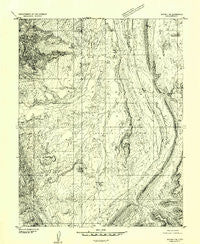
~ Notom 4 SE UT topo map, 1:24000 scale, 7.5 X 7.5 Minute, Historical, 1952, updated 1954
Notom 4 SE, Utah, USGS topographic map dated 1952.
Includes geographic coordinates (latitude and longitude). This topographic map is suitable for hiking, camping, and exploring, or framing it as a wall map.
Printed on-demand using high resolution imagery, on heavy weight and acid free paper, or alternatively on a variety of synthetic materials.
Topos available on paper, Waterproof, Poly, or Tyvek. Usually shipping rolled, unless combined with other folded maps in one order.
- Product Number: USGS-5459653
- Free digital map download (high-resolution, GeoPDF): Notom 4 SE, Utah (file size: 12 MB)
- Map Size: please refer to the dimensions of the GeoPDF map above
- Weight (paper map): ca. 55 grams
- Map Type: POD USGS Topographic Map
- Map Series: HTMC
- Map Verison: Historical
- Cell ID: 39832
- Scan ID: 251044
- Imprint Year: 1954
- Aerial Photo Year: 1951
- Datum: Unstated
- Map Projection: Unstated
- Preliminary map: Yes
- Map published by United States Geological Survey
- Keywords: Nonstandard Press Run
- Map Language: English
- Scanner Resolution: 600 dpi
- Map Cell Name: Sandy Creek Benches
- Grid size: 7.5 X 7.5 Minute
- Date on map: 1952
- Map Scale: 1:24000
- Geographical region: Utah, United States
Neighboring Maps:
All neighboring USGS topo maps are available for sale online at a variety of scales.
Spatial coverage:
Topo map Notom 4 SE, Utah, covers the geographical area associated the following places:
- North Coleman Canyon - Sheets Gulch - South Coleman Canyon - Divide Canyon - Spring Canyon - Red Canyon - Cedar Mesa - Sandy Draw - Wildcat Mesa - Oak Creek - The Narrows - Blind Trail - Cedar Mesa Campground - Sandy Creek Benches - Water Pocket Fold - Elbow of the Sandy - Sandy Ranch
- Map Area ID: AREA38.12538-111.125-111
- Northwest corner Lat/Long code: USGSNW38.125-111.125
- Northeast corner Lat/Long code: USGSNE38.125-111
- Southwest corner Lat/Long code: USGSSW38-111.125
- Southeast corner Lat/Long code: USGSSE38-111
- Northern map edge Latitude: 38.125
- Southern map edge Latitude: 38
- Western map edge Longitude: -111.125
- Eastern map edge Longitude: -111


