
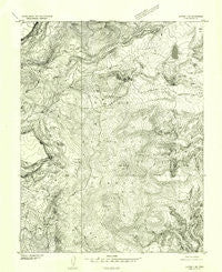
~ Notom 3 SE UT topo map, 1:24000 scale, 7.5 X 7.5 Minute, Historical, 1952, updated 1954
Notom 3 SE, Utah, USGS topographic map dated 1952.
Includes geographic coordinates (latitude and longitude). This topographic map is suitable for hiking, camping, and exploring, or framing it as a wall map.
Printed on-demand using high resolution imagery, on heavy weight and acid free paper, or alternatively on a variety of synthetic materials.
Topos available on paper, Waterproof, Poly, or Tyvek. Usually shipping rolled, unless combined with other folded maps in one order.
- Product Number: USGS-5459645
- Free digital map download (high-resolution, GeoPDF): Notom 3 SE, Utah (file size: 13 MB)
- Map Size: please refer to the dimensions of the GeoPDF map above
- Weight (paper map): ca. 55 grams
- Map Type: POD USGS Topographic Map
- Map Series: HTMC
- Map Verison: Historical
- Cell ID: 26788
- Scan ID: 251037
- Imprint Year: 1954
- Aerial Photo Year: 1951
- Datum: Unstated
- Map Projection: Unstated
- Preliminary map: Yes
- Map published by United States Geological Survey
- Keywords: Nonstandard Press Run
- Map Language: English
- Scanner Resolution: 600 dpi
- Map Cell Name: Lower Bowns Reservoir
- Grid size: 7.5 X 7.5 Minute
- Date on map: 1952
- Map Scale: 1:24000
- Geographical region: Utah, United States
Neighboring Maps:
All neighboring USGS topo maps are available for sale online at a variety of scales.
Spatial coverage:
Topo map Notom 3 SE, Utah, covers the geographical area associated the following places:
- Oak Creek Campground - Blue Grass Lake - Bowns Lake - Parks Pasture - Wildcat Ranger Station - Behanin Creek - Steep Creek Lake - Pine Creek Campground - Sunflower Flat - Aspen Spring - Lower Bowns Reservoir - Oak Creek Forest Camp - Point Lookout - Cons Knoll - The Terrace - Keller Knoll - Bowns Point - Jorgenson Flat - Long Lake - Scout Lake - Pole Corral Draw - Park Ridge - Dry Bench - Wildcat Pasture - Windmill Ridge - Wildcat Creek - Blue Grass - Cons Hole - Bowns Reservoir - Lower Bown Campground - Oak Creek Reservoir - Aspen Point - Spruce Spring - Bowery Flat - Oak Creek Dam - Edmunds Hole - Roundup Flat - Sawmill Bench - Big Ridge - Pleasant Creek Campground - Dunfey Creek - Round Lake - Lower Bowns Dam - Bear Flat
- Map Area ID: AREA38.12538-111.375-111.25
- Northwest corner Lat/Long code: USGSNW38.125-111.375
- Northeast corner Lat/Long code: USGSNE38.125-111.25
- Southwest corner Lat/Long code: USGSSW38-111.375
- Southeast corner Lat/Long code: USGSSE38-111.25
- Northern map edge Latitude: 38.125
- Southern map edge Latitude: 38
- Western map edge Longitude: -111.375
- Eastern map edge Longitude: -111.25


