
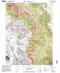
~ North Ogden UT topo map, 1:24000 scale, 7.5 X 7.5 Minute, Historical, 1998, updated 2001
North Ogden, Utah, USGS topographic map dated 1998.
Includes geographic coordinates (latitude and longitude). This topographic map is suitable for hiking, camping, and exploring, or framing it as a wall map.
Printed on-demand using high resolution imagery, on heavy weight and acid free paper, or alternatively on a variety of synthetic materials.
Topos available on paper, Waterproof, Poly, or Tyvek. Usually shipping rolled, unless combined with other folded maps in one order.
- Product Number: USGS-5459611
- Free digital map download (high-resolution, GeoPDF): North Ogden, Utah (file size: 21 MB)
- Map Size: please refer to the dimensions of the GeoPDF map above
- Weight (paper map): ca. 55 grams
- Map Type: POD USGS Topographic Map
- Map Series: HTMC
- Map Verison: Historical
- Cell ID: 32434
- Scan ID: 251003
- Imprint Year: 2001
- Woodland Tint: Yes
- Aerial Photo Year: 1997
- Edit Year: 1998
- Datum: NAD27
- Map Projection: Lambert Conformal Conic
- Map published by United States Geological Survey
- Map published by United States Forest Service
- Map Language: English
- Scanner Resolution: 600 dpi
- Map Cell Name: North Ogden
- Grid size: 7.5 X 7.5 Minute
- Date on map: 1998
- Map Scale: 1:24000
- Geographical region: Utah, United States
Neighboring Maps:
All neighboring USGS topo maps are available for sale online at a variety of scales.
Spatial coverage:
Topo map North Ogden, Utah, covers the geographical area associated the following places:
- Parkwood Estates Condominium - Lefgren - Green Meadows - Anderwood Estates - Mountain Orchard Estates - Panorama Heights - Jumpoff Canyon - Urban Estates Mobile - Green Acres Estates - White Barn Country Club - Downs - Crystal Manor Condominium - Majestic Heights - Northridge - Eyrie Meadows - Mountain Meadows Estates - Best View Estates - Lancer Acres - East Ridge - The Hermitage - The Colony - Pleasant Acres - Alta Vista - Hill Top - Tamarack - Sherwood Park Addition - Cobble Creek Park - North Heights - Suncrest Park - Marvella Heights - El Rancho Ogden Addition - Bailey - Keystone Acres - Centennial Condominium - Washington Avenue Addition - Cherrywood - Melody Lane - Paradise Acres - North Park - Orchard Grove Annex - Misty Meadows - Rockcliff Addition - Esquire - Ye Olde Farm - Cherry Hill Addition - Otto Berger Addition - Packer Place - Cliff Heights - Colonial Hills - Wedells Five Point Addition - Stettler - Majestic View Homes - Garfield Addition - Mountain Crest - North Ogden - Model Addition - Quail Run - Cropseys Addition - Simmons - Hermitage - Jillville - Fairway Park - Cottonwood Heights - Majestic Heights Ten - Lomond View Addition - Willowbrook - Myers Addition - Academy Heights - Walnut Hill Addition - Monterey Addition - Circle View - Parkwood Estates - Edgemont - Cold Water Estates - Harrisville - Cropseys Addition Three - Wm Lunds Lynne Addition - Ben Lomond Park - Simoran Park Addition - Hale Annex - East Lynne Addition - Protzman - Academy Heights Addition - Sheridan Heights - Hi Vista - Woodfield Estates - Shady Brook - Pleasant View - Avalon Hills - Sunny Slope - Willowcreek - Cinnamon Park - Weber View - Sun Crest Heights - Carr - Townside Park - Mountain Estates - Ron Clare Village - Lexington Square - Meadowlark Meadows
- Map Area ID: AREA41.37541.25-112-111.875
- Northwest corner Lat/Long code: USGSNW41.375-112
- Northeast corner Lat/Long code: USGSNE41.375-111.875
- Southwest corner Lat/Long code: USGSSW41.25-112
- Southeast corner Lat/Long code: USGSSE41.25-111.875
- Northern map edge Latitude: 41.375
- Southern map edge Latitude: 41.25
- Western map edge Longitude: -112
- Eastern map edge Longitude: -111.875


