
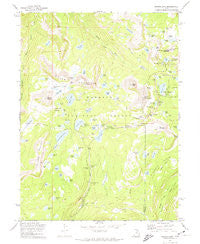
~ Mirror Lake UT topo map, 1:24000 scale, 7.5 X 7.5 Minute, Historical, 1972, updated 1974
Mirror Lake, Utah, USGS topographic map dated 1972.
Includes geographic coordinates (latitude and longitude). This topographic map is suitable for hiking, camping, and exploring, or framing it as a wall map.
Printed on-demand using high resolution imagery, on heavy weight and acid free paper, or alternatively on a variety of synthetic materials.
Topos available on paper, Waterproof, Poly, or Tyvek. Usually shipping rolled, unless combined with other folded maps in one order.
- Product Number: USGS-5459067
- Free digital map download (high-resolution, GeoPDF): Mirror Lake, Utah (file size: 11 MB)
- Map Size: please refer to the dimensions of the GeoPDF map above
- Weight (paper map): ca. 55 grams
- Map Type: POD USGS Topographic Map
- Map Series: HTMC
- Map Verison: Historical
- Cell ID: 29609
- Scan ID: 250608
- Imprint Year: 1974
- Woodland Tint: Yes
- Aerial Photo Year: 1967
- Field Check Year: 1972
- Datum: NAD27
- Map Projection: Lambert Conformal Conic
- Map published by United States Geological Survey
- Map published by United States Forest Service
- Map Language: English
- Scanner Resolution: 600 dpi
- Map Cell Name: Mirror Lake
- Grid size: 7.5 X 7.5 Minute
- Date on map: 1972
- Map Scale: 1:24000
- Geographical region: Utah, United States
Neighboring Maps:
All neighboring USGS topo maps are available for sale online at a variety of scales.
Spatial coverage:
Topo map Mirror Lake, Utah, covers the geographical area associated the following places:
- Mirror Lake Campground - Cliff Lake Dam - Meadow Lake - Spectacle Lake - Moosehorn Lake - Booker Lake - Lost Lake - Bonnie Lake - Ponds Lake - Broadwater Meadows - Trial Lake Campground - Joan Lake - John Lake - Blue Lake - Haystack Lake - Lost Creek Campground - Lily Lakes - Upper Provo Bridge Picnic Area - Pass Lake - Pyramid Lake - Three Divide Lakes - Mirror Lake - Abes Lake Dam - Washington Lake Dam - Wilderness Area Overlook - Castle Lake - Camp Steiner - Marjorie Lake Dam - Tarwood Flat - Ruth Lake - Fehr Lake - Lilly Lake - Star Lake Dam - Notch Mountain - Crystal Lake - Broadhead Meadows - Shallow Lake - Petit Lake - Lovenia Lake - Buckeye Lake - Dean Lake - Rock Lake - Scout Lake - Cliff Lake - Weir Reservoir - Provo River Falls - Peter Lake - Mirror Lake Guard Station - Cutthroat Lake - Abes Lake - Pearl Lake - Marjorie Lake - Wall Lake Dam - Notch Lake - Picturesque Lake - Twin Lakes - Long Lake - Cliff Lake - Clegg Lake - Jewel Lake - Trial Lake Dam - Provo River Falls Overlook - Seymour Meadow Lake Dam - Echo Lake - Slate Gorge - Diamond Lake - Crystal Lake Trail Head - Mount Cardwell - Fir Lake - Star Lake - Gem Lake - Haystack Mountain - Clyde Lake - Notch Mountain Trail - Tail Lake - Reids Meadow - North Twin Lake - Beth Lake - Blizzard Lake - Hope Lake - South Twin Lake - Washington Lake - Lost Lake Number Two - Kamas Lake - Hidden Lake - Trial Lake - Reids Lake - The Notch - Watson Lake - Teal Lake - Bald Mountain Overlook - Lofty Lake Trail - Pass Lake Trailhead - Kamas Lake Dam - Bench Lake - Meadow Lake - Lost Lake Dam - Hayden Lake - Lake Marion - Long Lake Dam
- Map Area ID: AREA40.7540.625-111-110.875
- Northwest corner Lat/Long code: USGSNW40.75-111
- Northeast corner Lat/Long code: USGSNE40.75-110.875
- Southwest corner Lat/Long code: USGSSW40.625-111
- Southeast corner Lat/Long code: USGSSE40.625-110.875
- Northern map edge Latitude: 40.75
- Southern map edge Latitude: 40.625
- Western map edge Longitude: -111
- Eastern map edge Longitude: -110.875


