
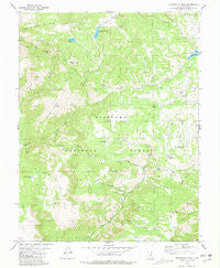
~ Marysvale Peak UT topo map, 1:24000 scale, 7.5 X 7.5 Minute, Historical, 1981, updated 1981
Marysvale Peak, Utah, USGS topographic map dated 1981.
Includes geographic coordinates (latitude and longitude). This topographic map is suitable for hiking, camping, and exploring, or framing it as a wall map.
Printed on-demand using high resolution imagery, on heavy weight and acid free paper, or alternatively on a variety of synthetic materials.
Topos available on paper, Waterproof, Poly, or Tyvek. Usually shipping rolled, unless combined with other folded maps in one order.
- Product Number: USGS-5458895
- Free digital map download (high-resolution, GeoPDF): Marysvale Peak, Utah (file size: 12 MB)
- Map Size: please refer to the dimensions of the GeoPDF map above
- Weight (paper map): ca. 55 grams
- Map Type: POD USGS Topographic Map
- Map Series: HTMC
- Map Verison: Historical
- Cell ID: 27923
- Scan ID: 250495
- Imprint Year: 1981
- Woodland Tint: Yes
- Aerial Photo Year: 1973
- Edit Year: 1981
- Field Check Year: 1975
- Datum: NAD27
- Map Projection: Lambert Conformal Conic
- Map published by United States Geological Survey
- Map Language: English
- Scanner Resolution: 600 dpi
- Map Cell Name: Marysvale Peak
- Grid size: 7.5 X 7.5 Minute
- Date on map: 1981
- Map Scale: 1:24000
- Geographical region: Utah, United States
Neighboring Maps:
All neighboring USGS topo maps are available for sale online at a variety of scales.
Spatial coverage:
Topo map Marysvale Peak, Utah, covers the geographical area associated the following places:
- Jass Dairy - Tuft Draw - Mud Spring Draw - Manning Meadows Dam - Mud Spring - Wills Reservoir - Straight Canyon - Burnt Flat - Anderson Dairy - Smith Canyon - Little Meadows Creek - Willis Reservoir - Manning Meadows Reservoir - Big Flat - Upper Box Creek Reservoir - Anderson Canyon - Dry Creek Guard Station - Dry Lake - Blackbird Mine - Smith Canyon Trail - Langdon Creek - Marysvale Peak - Voyles Pond - Cold Springs - North Fork Box Creek - Little Meadows - East Fork - Dyches Draw - Vale Creek - Big Flat Reservoir - Six Patch Draw - Ogden Cabin - Upper Box Creek Dam - Burnt Flat Reservoir - Middle Spring Lake - Bean Hill - Willow Spring - Langdon Mountain - Manning Meadows - Miners Ridge - Big Table - Little Table - Barney Lake Reservoir Dam - White Ledge Spring - Rock Spring - Mud Spring - Barney Lake - Rudd Spring Creek - Browns Dairy - Windy Ridge - Left Fork Dry Creek
- Map Area ID: AREA38.538.375-112.125-112
- Northwest corner Lat/Long code: USGSNW38.5-112.125
- Northeast corner Lat/Long code: USGSNE38.5-112
- Southwest corner Lat/Long code: USGSSW38.375-112.125
- Southeast corner Lat/Long code: USGSSE38.375-112
- Northern map edge Latitude: 38.5
- Southern map edge Latitude: 38.375
- Western map edge Longitude: -112.125
- Eastern map edge Longitude: -112


