
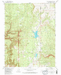
~ Kolob Reservoir UT topo map, 1:24000 scale, 7.5 X 7.5 Minute, Historical, 1980, updated 1981
Kolob Reservoir, Utah, USGS topographic map dated 1980.
Includes geographic coordinates (latitude and longitude). This topographic map is suitable for hiking, camping, and exploring, or framing it as a wall map.
Printed on-demand using high resolution imagery, on heavy weight and acid free paper, or alternatively on a variety of synthetic materials.
Topos available on paper, Waterproof, Poly, or Tyvek. Usually shipping rolled, unless combined with other folded maps in one order.
- Product Number: USGS-5458461
- Free digital map download (high-resolution, GeoPDF): Kolob Reservoir, Utah (file size: 15 MB)
- Map Size: please refer to the dimensions of the GeoPDF map above
- Weight (paper map): ca. 55 grams
- Map Type: POD USGS Topographic Map
- Map Series: HTMC
- Map Verison: Historical
- Cell ID: 23943
- Scan ID: 250180
- Imprint Year: 1981
- Woodland Tint: Yes
- Aerial Photo Year: 1973
- Edit Year: 1980
- Field Check Year: 1974
- Datum: NAD27
- Map Projection: Lambert Conformal Conic
- Map published by United States Geological Survey
- Map Language: English
- Scanner Resolution: 600 dpi
- Map Cell Name: Kolob Reservoir
- Grid size: 7.5 X 7.5 Minute
- Date on map: 1980
- Map Scale: 1:24000
- Geographical region: Utah, United States
Neighboring Maps:
All neighboring USGS topo maps are available for sale online at a variety of scales.
Spatial coverage:
Topo map Kolob Reservoir, Utah, covers the geographical area associated the following places:
- Spillsbury Ranch - Kolob Creek Dam - Bear Trap Canyon - Oak Spring - Kolob Reservoir - Bear Creek - Willis Creek - Chasm Lake - Lamareau Ranch - Bear Canyon - Blue Springs Reservoir - Upper Kolob Plateau - KGSU-FM (Cedar City) - Lower Kolob Plateau - The Pillars - Sevy Ranch - LaVerkin Creek Wilderness - Lava Point Campground - Mud Spring - Beebe Hollow - Goose Creek Knoll - Hornet Point - Meadow Hollow Reservoir - Long Point - House Spring - Willow Creek - Home Valley Knoll - Birch Spring - Blue Springs - The Hardscrabble - Little Creek Peak - Beartrap Canyon Wilderness - Langston Mountain - Bullpen Mountain - Pine Hollow - Spring Creek Ditch - Blue Springs Reservoir Dam - Kolob Peak - Meadow Hollow Dam - Kolob Creek Reservoir - Meadow Hollow - Bear Valley - Indian Hollow - Lava Point
- Map Area ID: AREA37.537.375-113.125-113
- Northwest corner Lat/Long code: USGSNW37.5-113.125
- Northeast corner Lat/Long code: USGSNE37.5-113
- Southwest corner Lat/Long code: USGSSW37.375-113.125
- Southeast corner Lat/Long code: USGSSE37.375-113
- Northern map edge Latitude: 37.5
- Southern map edge Latitude: 37.375
- Western map edge Longitude: -113.125
- Eastern map edge Longitude: -113


