
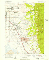
~ Kaysville UT topo map, 1:24000 scale, 7.5 X 7.5 Minute, Historical, 1955, updated 1956
Kaysville, Utah, USGS topographic map dated 1955.
Includes geographic coordinates (latitude and longitude). This topographic map is suitable for hiking, camping, and exploring, or framing it as a wall map.
Printed on-demand using high resolution imagery, on heavy weight and acid free paper, or alternatively on a variety of synthetic materials.
Topos available on paper, Waterproof, Poly, or Tyvek. Usually shipping rolled, unless combined with other folded maps in one order.
- Product Number: USGS-5458369
- Free digital map download (high-resolution, GeoPDF): Kaysville, Utah (file size: 12 MB)
- Map Size: please refer to the dimensions of the GeoPDF map above
- Weight (paper map): ca. 55 grams
- Map Type: POD USGS Topographic Map
- Map Series: HTMC
- Map Verison: Historical
- Cell ID: 23103
- Scan ID: 250117
- Imprint Year: 1956
- Woodland Tint: Yes
- Aerial Photo Year: 1953
- Field Check Year: 1955
- Survey Year: 1926
- Datum: NAD27
- Map Projection: Polyconic
- Map published by United States Geological Survey
- Map published by United States Army Corps of Engineers
- Map published by United States Army
- Map Language: English
- Scanner Resolution: 600 dpi
- Map Cell Name: Kaysville
- Grid size: 7.5 X 7.5 Minute
- Date on map: 1955
- Map Scale: 1:24000
- Geographical region: Utah, United States
Neighboring Maps:
All neighboring USGS topo maps are available for sale online at a variety of scales.
Spatial coverage:
Topo map Kaysville, Utah, covers the geographical area associated the following places:
- Ridgeview Park - Deerfield - Wheat Ridge - Fairway Fields - Ridge Crest Estates - Kimberly Meadows - Rosmait Park - Cresthomes Addition - Oakridge Place - Natural Estates - Homeplace - Hodson Estates - Pleasant Hills - Layton Meadows Condominium - Fairfield Estates - Hidden Hollow - The Meadows - Oakridge Farms - Rolling Oaks - Eastwood Estates - Millcreek Estates - Robinwood - Aura Acres - Dimond Oaks - Laytona - Oakridge Village - Gill - Cottonwood - Golden Acres - Spurlock Circle - Spencer Estates - Meadows at Mutton Hollow Condominium - Deer Run Estates - Kens - Robins Park One and Two - Oakmont Acres - Summer Haze - Fort Lane Plaza Condominium - Avion Vista - Upland - Snow Canyon - Jamestown - Quail Hollow - Kays Creek - Koziar Hills - Clover Estates - Mount Dell - Misty Meadows - Vantage Park - Woodridge Twin Homes - Hob Hill - North Hills Estates - Kay Lyn Manor - Victorian Oaks - Fairfield Condominium - Country Creek Estates - Alta Acres - Sahara Village - Green Mountain Estates - Layton - Glendale Gardens - West Kaysville - Holt - Royal Farms Estates - Aspen East - Country Estates - Somerset Farm - Parkdale - Kaysville Heights - Nayon Heights Condominium - Jones - Indian Oaks - Diamond Hills - Layton Park Plaza Condominium - Leedot Heights - Hidden Hideaway Condominium - Wooded Hills - The Orchard - Meadow Hollow Condominium - Grand Oaks - Fernwood Hollow - King Clarion Hills - Colonial Park - Colonies of East Pointe - Mount Air Estates - Woodridge Estates - Holmes Hollow Estates - Lakeland - LaDonna Mesa - David Smith - Oakridge Terrace - Canyon Cove Estates - Eastridge Estates - Cook - Phillips - Country Oaks Condominium - Hillside Estates - Twin Creek Estates - Barton Manor Three - Barnes Estates
- Map Area ID: AREA41.12541-112-111.875
- Northwest corner Lat/Long code: USGSNW41.125-112
- Northeast corner Lat/Long code: USGSNE41.125-111.875
- Southwest corner Lat/Long code: USGSSW41-112
- Southeast corner Lat/Long code: USGSSE41-111.875
- Northern map edge Latitude: 41.125
- Southern map edge Latitude: 41
- Western map edge Longitude: -112
- Eastern map edge Longitude: -111.875


