
~ Iron Mine Mountain UT topo map, 1:24000 scale, 7.5 X 7.5 Minute, Historical, 1972, updated 1974
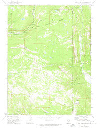
Iron Mine Mountain, Utah, USGS topographic map dated 1972.
Includes geographic coordinates (latitude and longitude). This topographic map is suitable for hiking, camping, and exploring, or framing it as a wall map.
Printed on-demand using high resolution imagery, on heavy weight and acid free paper, or alternatively on a variety of synthetic materials.
Topos available on paper, Waterproof, Poly, or Tyvek. Usually shipping rolled, unless combined with other folded maps in one order.
- Product Number: USGS-5458159
- Free digital map download (high-resolution, GeoPDF): Iron Mine Mountain, Utah (file size: 10 MB)
- Map Size: please refer to the dimensions of the GeoPDF map above
- Weight (paper map): ca. 55 grams
- Map Type: POD USGS Topographic Map
- Map Series: HTMC
- Map Verison: Historical
- Cell ID: 22058
- Scan ID: 249964
- Imprint Year: 1974
- Woodland Tint: Yes
- Aerial Photo Year: 1967
- Field Check Year: 1972
- Datum: NAD27
- Map Projection: Lambert Conformal Conic
- Map published by United States Geological Survey
- Map published by United States Forest Service
- Map Language: English
- Scanner Resolution: 600 dpi
- Map Cell Name: Iron Mine Mountain
- Grid size: 7.5 X 7.5 Minute
- Date on map: 1972
- Map Scale: 1:24000
- Geographical region: Utah, United States
Neighboring Maps:
All neighboring USGS topo maps are available for sale online at a variety of scales.
Spatial coverage:
Topo map Iron Mine Mountain, Utah, covers the geographical area associated the following places:
- Trail Hollow - Cobblerest Campground - Cataract Gorge - Cold Spring - Iron Mine Mountain - Defas Dude Ranch - Spruce Springs Reservoir - Duchesne Monument - Lambert Meadow - Mill Flat - Smooth Rock Falls - Cobble Creek - East Portal - Mill Flat Campground - Hades Rhoades Tunnel - Iron Mine Creek - Hades Recreation Site - Shale Creek - Little Pond - Beaver Creek - Duchesne Tunnel - Broadhead Lake - Little Deer Creek - Iron Mine Lake - West Portal - Alexander Lake - Iron Mine Campground - East Portal Duchesne Tunnel
- Map Area ID: AREA40.62540.5-111-110.875
- Northwest corner Lat/Long code: USGSNW40.625-111
- Northeast corner Lat/Long code: USGSNE40.625-110.875
- Southwest corner Lat/Long code: USGSSW40.5-111
- Southeast corner Lat/Long code: USGSSE40.5-110.875
- Northern map edge Latitude: 40.625
- Southern map edge Latitude: 40.5
- Western map edge Longitude: -111
- Eastern map edge Longitude: -110.875


