
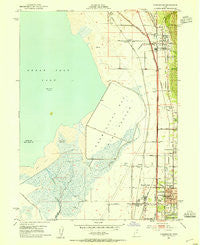
~ Farmington UT topo map, 1:24000 scale, 7.5 X 7.5 Minute, Historical, 1952, updated 1954
Farmington, Utah, USGS topographic map dated 1952.
Includes geographic coordinates (latitude and longitude). This topographic map is suitable for hiking, camping, and exploring, or framing it as a wall map.
Printed on-demand using high resolution imagery, on heavy weight and acid free paper, or alternatively on a variety of synthetic materials.
Topos available on paper, Waterproof, Poly, or Tyvek. Usually shipping rolled, unless combined with other folded maps in one order.
- Product Number: USGS-5457205
- Free digital map download (high-resolution, GeoPDF): Farmington, Utah (file size: 10 MB)
- Map Size: please refer to the dimensions of the GeoPDF map above
- Weight (paper map): ca. 55 grams
- Map Type: POD USGS Topographic Map
- Map Series: HTMC
- Map Verison: Historical
- Cell ID: 15027
- Scan ID: 249244
- Imprint Year: 1954
- Woodland Tint: Yes
- Aerial Photo Year: 1950
- Field Check Year: 1952
- Survey Year: 1926
- Datum: NAD27
- Map Projection: Polyconic
- Map published by United States Geological Survey
- Map Language: English
- Scanner Resolution: 600 dpi
- Map Cell Name: Farmington
- Grid size: 7.5 X 7.5 Minute
- Date on map: 1952
- Map Scale: 1:24000
- Geographical region: Utah, United States
Neighboring Maps:
All neighboring USGS topo maps are available for sale online at a variety of scales.
Spatial coverage:
Topo map Farmington, Utah, covers the geographical area associated the following places:
- Rolling Hills Estates - Quail Cove - Bonito Verde - The Pines - Williams West - Peach Tree Condominium - Glendale - Bountiful Gardens Apartment Homes - Willow Farm Estates - Lakeview Condominiums of Bountiful - Ruflin Acres - East Chapel - LaVista Park - South Main Townhouses - Green Meadows - West Woods Mobile Homes PUD - Meadowlane - Stephens - Chase Lane West - Raynor Acres - Susie Ranch - Evergreen Acres - Casa Loma - Birdland - Country Station Condominium - Elliot Estates - Birdella Park - Park View - Croper - Chase Lane Estates - Charnell - Placid Cove - Meadow Springs - Steed Creek Estates - Telford - The Courtyard Condominium - Van Dyke and Willey Condominium - Bountiful Park - Sunny Slope - L Marlene Villa - Hight - Sunset View Estates - Carriage Crossing Condominium - Smoot Farm Estates - Plat A - Mountainside - Bayview Heights - Thirteenth South - Floral Grove Estates - Hogan Park - Aegean Village - Parrish Park - Ruflin Circle - Duncan Estates - Pitford Acres - Colonial - Applewood Estates - Continental Townhouse Condominium - Surrey Downs - Parrish Heights - Evergreen - Rolling Hills Meadows - Fackrell - Farmington Heights - Holbrook - Lakeview Hills - Tanglewood Acres - Cave Hollow - Oak Lane - Meadowbrook Acres - Chapel - Meadowbrook - Pheasantbrook - Kirkhaven - Homestead Condominium - Cherry Park - Lemontree Condominium - Bridle Acres - Judge Holbrook - Lynnhaven - Manna Acres - Quail Run - Danbury Lane Condominium - Summertree - Valencia - Kum-Li Meadows - Sport Sales Plaza - Campbell - Benchmark Village - Ridgeview Estates - McKean Estates - Continental Estates - Stone Creek - Rosedale Estates - Farmington - Woodland Springs - Smoot Farm Estates - J Hill Johnson - Deuel Creek Estates - A and K - Center Village
- Map Area ID: AREA4140.875-112-111.875
- Northwest corner Lat/Long code: USGSNW41-112
- Northeast corner Lat/Long code: USGSNE41-111.875
- Southwest corner Lat/Long code: USGSSW40.875-112
- Southeast corner Lat/Long code: USGSSE40.875-111.875
- Northern map edge Latitude: 41
- Southern map edge Latitude: 40.875
- Western map edge Longitude: -112
- Eastern map edge Longitude: -111.875


