
~ Explorer Peak UT topo map, 1:24000 scale, 7.5 X 7.5 Minute, Historical, 1967, updated 1968
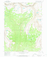
Explorer Peak, Utah, USGS topographic map dated 1967.
Includes geographic coordinates (latitude and longitude). This topographic map is suitable for hiking, camping, and exploring, or framing it as a wall map.
Printed on-demand using high resolution imagery, on heavy weight and acid free paper, or alternatively on a variety of synthetic materials.
Topos available on paper, Waterproof, Poly, or Tyvek. Usually shipping rolled, unless combined with other folded maps in one order.
- Product Number: USGS-5457173
- Free digital map download (high-resolution, GeoPDF): Explorer Peak, Utah (file size: 10 MB)
- Map Size: please refer to the dimensions of the GeoPDF map above
- Weight (paper map): ca. 55 grams
- Map Type: POD USGS Topographic Map
- Map Series: HTMC
- Map Verison: Historical
- Cell ID: 14745
- Scan ID: 249213
- Imprint Year: 1968
- Woodland Tint: Yes
- Aerial Photo Year: 1966
- Field Check Year: 1967
- Datum: NAD27
- Map Projection: Polyconic
- Map published by United States Geological Survey
- Map published by United States Bureau of Reclamation
- Map Language: English
- Scanner Resolution: 600 dpi
- Map Cell Name: Explorer Peak
- Grid size: 7.5 X 7.5 Minute
- Date on map: 1967
- Map Scale: 1:24000
- Geographical region: Utah, United States
Neighboring Maps:
All neighboring USGS topo maps are available for sale online at a variety of scales.
Spatial coverage:
Topo map Explorer Peak, Utah, covers the geographical area associated the following places:
- Squaw Basin - Bench Lake - Young Lake - Rock Lakes - Slide Lake - Crater Lake - Boot Lake - Ledge Lake - Cleveland Peak - Phinney Lake - Squaw Lake - Helen Lake - Fall Creek - Jack and Jill Lakes - Cyclone Pass - Black Lake - Triangle Lake - Explorer Peak - Sea Lion Lake - Anderson Lake - Shamrock Lake - Brinkley Lake - Fall Lakes - Reconnaissance Lake - Doug Lake - Dead Horse Lake - Squaw Basin Creek - Ouray Lake - Lower Ottoson Lake - Thompson Lake - Squaw Peak - Big Meadow - Continent Lake - Big Meadow Forest Service Station - Francis Lake - Jodie Lake - Dead Horse Pass - Upper Ottoson Lake
- Map Area ID: AREA40.7540.625-110.75-110.625
- Northwest corner Lat/Long code: USGSNW40.75-110.75
- Northeast corner Lat/Long code: USGSNE40.75-110.625
- Southwest corner Lat/Long code: USGSSW40.625-110.75
- Southeast corner Lat/Long code: USGSSE40.625-110.625
- Northern map edge Latitude: 40.75
- Southern map edge Latitude: 40.625
- Western map edge Longitude: -110.75
- Eastern map edge Longitude: -110.625


