
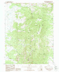
~ Bearskin Mountain UT topo map, 1:24000 scale, 7.5 X 7.5 Minute, Historical, 1986, updated 1986
Bearskin Mountain, Utah, USGS topographic map dated 1986.
Includes geographic coordinates (latitude and longitude). This topographic map is suitable for hiking, camping, and exploring, or framing it as a wall map.
Printed on-demand using high resolution imagery, on heavy weight and acid free paper, or alternatively on a variety of synthetic materials.
Topos available on paper, Waterproof, Poly, or Tyvek. Usually shipping rolled, unless combined with other folded maps in one order.
- Product Number: USGS-5455509
- Free digital map download (high-resolution, GeoPDF): Bearskin Mountain, Utah (file size: 14 MB)
- Map Size: please refer to the dimensions of the GeoPDF map above
- Weight (paper map): ca. 55 grams
- Map Type: POD USGS Topographic Map
- Map Series: HTMC
- Map Verison: Historical
- Cell ID: 2876
- Scan ID: 248026
- Imprint Year: 1986
- Woodland Tint: Yes
- Aerial Photo Year: 1983
- Edit Year: 1986
- Field Check Year: 1984
- Datum: NAD27
- Map Projection: Lambert Conformal Conic
- Provisional map: Yes
- Map published by United States Geological Survey
- Map Language: English
- Scanner Resolution: 600 dpi
- Map Cell Name: Bearskin Mountain
- Grid size: 7.5 X 7.5 Minute
- Date on map: 1986
- Map Scale: 1:24000
- Geographical region: Utah, United States
Neighboring Maps:
All neighboring USGS topo maps are available for sale online at a variety of scales.
Spatial coverage:
Topo map Bearskin Mountain, Utah, covers the geographical area associated the following places:
- Granite Peak - Bettie Spring - Bailey Spring - Little Bearskin Mountain - Wycroft Spring - Milford Needle - Carlyle Spring - Old Indian Spring - Right Fork Ranch Canyon - Sunnyside Hollow - Pumice Hole Mine - Mathew Spring - Left Fork Ranch Canyon - Burnt Hollow - Schoo Mine - Granite Rock Spring - Bailey Mountain - Bearskin Flat - Patterson Hollow - Wildhorse Mountain - Ryan Ranch - Boulder Spring - Little Cedar Cove - Shag Hollow - Wildhorse Spring - Upper Bailey Spring - Left Fork Wildhorse Canyon - Wycroft Canyon - Bailey Ridge - Willow Spring - Kirk Spring - Kirk Canyon - Big Cedar Cove - South Twin Flat Mountain - Wildhorse Canyon - Bearskin Mountain - Wildcat Hollow - The Park - West Park Spring - North Twin Flat Mountain - Jackrabbit Spring
- Map Area ID: AREA38.538.375-112.875-112.75
- Northwest corner Lat/Long code: USGSNW38.5-112.875
- Northeast corner Lat/Long code: USGSNE38.5-112.75
- Southwest corner Lat/Long code: USGSSW38.375-112.875
- Southeast corner Lat/Long code: USGSSE38.375-112.75
- Northern map edge Latitude: 38.5
- Southern map edge Latitude: 38.375
- Western map edge Longitude: -112.875
- Eastern map edge Longitude: -112.75


