
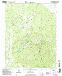
~ Barker Reservoir UT topo map, 1:24000 scale, 7.5 X 7.5 Minute, Historical, 2002, updated 2005
Barker Reservoir, Utah, USGS topographic map dated 2002.
Includes geographic coordinates (latitude and longitude). This topographic map is suitable for hiking, camping, and exploring, or framing it as a wall map.
Printed on-demand using high resolution imagery, on heavy weight and acid free paper, or alternatively on a variety of synthetic materials.
Topos available on paper, Waterproof, Poly, or Tyvek. Usually shipping rolled, unless combined with other folded maps in one order.
- Product Number: USGS-5455489
- Free digital map download (high-resolution, GeoPDF): Barker Reservoir, Utah (file size: 12 MB)
- Map Size: please refer to the dimensions of the GeoPDF map above
- Weight (paper map): ca. 55 grams
- Map Type: POD USGS Topographic Map
- Map Series: HTMC
- Map Verison: Historical
- Cell ID: 2411
- Scan ID: 248010
- Imprint Year: 2005
- Woodland Tint: Yes
- Aerial Photo Year: 1998
- Edit Year: 2002
- Datum: NAD27
- Map Projection: Lambert Conformal Conic
- Map published by United States Geological Survey
- Map published by United States Forest Service
- Map Language: English
- Scanner Resolution: 600 dpi
- Map Cell Name: Barker Reservoir
- Grid size: 7.5 X 7.5 Minute
- Date on map: 2002
- Map Scale: 1:24000
- Geographical region: Utah, United States
Neighboring Maps:
All neighboring USGS topo maps are available for sale online at a variety of scales.
Spatial coverage:
Topo map Barker Reservoir, Utah, covers the geographical area associated the following places:
- Yellow Lake - Holbys Bottom - Lower Barker Dam - Clayton Spring - Gibbons Springs - Velvet Lake - Sink Holes - White Creek - The Gap - Beck Hollow - Mud Lake - Lower Barker Reservoir - Barker Dam - Long Willow Bottom Reservoir - Rock Lake - Long Willow Bottom Dam - White Ranch - Tall Four Reservoir - Indian Spring Draw - Joe Lay Reservoir - Gates Spring - Barker Reservoir - Dougherty Basin - Flat Lake - Iron Spring - Escalante Mountains - Twitchell Creek - Griffin Creek - Blue Lake - Round Willow Bottom Reservoir - Three Springs - Barker Reservoir Campground - Griffin Spring - Whites Flat
- Map Area ID: AREA3837.875-111.875-111.75
- Northwest corner Lat/Long code: USGSNW38-111.875
- Northeast corner Lat/Long code: USGSNE38-111.75
- Southwest corner Lat/Long code: USGSSW37.875-111.875
- Southeast corner Lat/Long code: USGSSE37.875-111.75
- Northern map edge Latitude: 38
- Southern map edge Latitude: 37.875
- Western map edge Longitude: -111.875
- Eastern map edge Longitude: -111.75


