
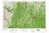
~ Huntington WV topo map, 1:250000 scale, 1 X 2 Degree, Historical, 1957, updated 1966
Huntington, West Virginia, USGS topographic map dated 1957.
Includes geographic coordinates (latitude and longitude). This topographic map is suitable for hiking, camping, and exploring, or framing it as a wall map.
Printed on-demand using high resolution imagery, on heavy weight and acid free paper, or alternatively on a variety of synthetic materials.
Topos available on paper, Waterproof, Poly, or Tyvek. Usually shipping rolled, unless combined with other folded maps in one order.
- Product Number: USGS-5416214
- Free digital map download (high-resolution, GeoPDF): Huntington, West Virginia (file size: 27 MB)
- Map Size: please refer to the dimensions of the GeoPDF map above
- Weight (paper map): ca. 55 grams
- Map Type: POD USGS Topographic Map
- Map Series: HTMC
- Map Verison: Historical
- Cell ID: 68832
- Scan ID: 254042
- Imprint Year: 1966
- Woodland Tint: Yes
- Photo Revision Year: 1966
- Aerial Photo Year: 1956
- Field Check Year: 1957
- Datum: Unstated
- Map Projection: Transverse Mercator
- Map published by United States Geological Survey
- Map Language: English
- Scanner Resolution: 600 dpi
- Map Cell Name: Huntington
- Grid size: 1 X 2 Degree
- Date on map: 1957
- Map Scale: 1:250000
- Geographical region: West Virginia, United States
Neighboring Maps:
All neighboring USGS topo maps are available for sale online at a variety of scales.
Spatial coverage:
Topo map Huntington, West Virginia, covers the geographical area associated the following places:
- Bartles - Norton Branch - Hillsboro - Weston - Bellmeade - Bald Point (historical) - Kinniconick - Fultz - Reid Village - Fairfield Acres - Tallwood Acres - Porterbrook - Willowvale - Dry Run - Arlee - Monroe - Brownstown (historical) - Clifford - Beartown - Straight Creek - McKitterick (historical) - Oak Hill (historical) - Offill's Mill (historical) - Clarksburg - Moorefield - Cox Landing - Leaper - Shannoah Town (historical) - Leatherwood (historical) - Brabant - Mercerville - Martha - Durbin - Andis - Rappsburg - Letitia - Guyandotte - Eldridge - Myra - Siloam - Anita Heights - Jacksonville - Helena - Gimlet - Shoals - Access - Rolling Hills - Petersburg - Wyett - Pleasant Valley Estates - Colfax - Sideway - Ore Mines (historical) - Stricklett - Quincy - Lincoln Park - Black Sulpher Spring (historical) - Beasley Fork - Ewington - Bowles - Grandview Heights - East Pea Ridge - York - Manley (historical) - South Point - Rome - Bethesda - Meads - Miller - Skaggs - Suddith (historical) - Devil Fork (historical) - Mabee Corner - Riverside Terrace - Walsh - Kerr - Carlton - Savage Branch - Firebrick - Pedro - Pink - Sherritts - Olive Hill - Feesburg - Beetle - Essex - Lisman - Green Valley (historical) - West Arnheim - Providence (historical) - Belle Court - Ribolt - Cottageville - Blue Creek - Bernie (historical) - Elmwood - Buck Run (historical) - Pond Run - Portersville - Gollihue
- Map Area ID: AREA3938-84-82
- Northwest corner Lat/Long code: USGSNW39-84
- Northeast corner Lat/Long code: USGSNE39-82
- Southwest corner Lat/Long code: USGSSW38-84
- Southeast corner Lat/Long code: USGSSE38-82
- Northern map edge Latitude: 39
- Southern map edge Latitude: 38
- Western map edge Longitude: -84
- Eastern map edge Longitude: -82


