
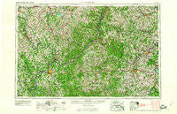
~ Clarksburg WV topo map, 1:250000 scale, 1 X 2 Degree, Historical, 1961, updated 1961
Clarksburg, West Virginia, USGS topographic map dated 1961.
Includes geographic coordinates (latitude and longitude). This topographic map is suitable for hiking, camping, and exploring, or framing it as a wall map.
Printed on-demand using high resolution imagery, on heavy weight and acid free paper, or alternatively on a variety of synthetic materials.
Topos available on paper, Waterproof, Poly, or Tyvek. Usually shipping rolled, unless combined with other folded maps in one order.
- Product Number: USGS-5416202
- Free digital map download (high-resolution, GeoPDF): Clarksburg, West Virginia (file size: 27 MB)
- Map Size: please refer to the dimensions of the GeoPDF map above
- Weight (paper map): ca. 55 grams
- Map Type: POD USGS Topographic Map
- Map Series: HTMC
- Map Verison: Historical
- Cell ID: 68718
- Scan ID: 254038
- Imprint Year: 1961
- Woodland Tint: Yes
- Aerial Photo Year: 1951
- Field Check Year: 1956
- Datum: Unstated
- Map Projection: Transverse Mercator
- Map published by United States Geological Survey
- Map Language: English
- Scanner Resolution: 600 dpi
- Map Cell Name: Clarksburg
- Grid size: 1 X 2 Degree
- Date on map: 1961
- Map Scale: 1:250000
- Geographical region: West Virginia, United States
Neighboring Maps:
All neighboring USGS topo maps are available for sale online at a variety of scales.
Spatial coverage:
Topo map Clarksburg, West Virginia, covers the geographical area associated the following places:
- Bucks Mill - Mount Tabor - Dart - Watertown - Morrisville - Consol Number 9 - Hayward - Duckworth - Hero - Robins - Conings - New Castle - Lawford - Booth - Jane Lew - Deep Valley - Cabinville (historical) - Pond Creek - Riverview - Lee Creek - Morningside - Carolina - Pecks Run - Spring Hill Chapel - Polandale - Putnam Place - Cloud (historical) - Slab - Trail Run (historical) - Porters Falls - Auburn - New Gottingen - Davisville - Mount Clare - Brohard - Cloverdale - Eden - Fairview Heights - Flaggy Meadow - Corbin (historical) - Kipling - Bickel Estates - Avondale - Sandhill - Dutchtown - McKinley (historical) - Franklin - Glendale Heights - Proctor - Elden (historical) - Relief - Brittain (historical) - McDonald - Vadis - Homewood - Ozark - Maloneys Mobile Home Park - Morford - Greencastle - Lippincott - Meighen - Way - Colfax - Elk City - West Waynesburg - Crisp (historical) - Hartshorn - Fort Grand - Round Bottom - Craigmoor - Cisco - Boaz - Four Mile - Scotts Run - Crabapple - Merriam - Georgetown - Sand Hill - Glendale - Midlan (historical) - North Hills - Flint - Klondike - Arlington Heights - Wesley (historical) - Marrtown - Greenwood Mobile Home Park - Cliffyville (historical) - Forest Hills - Haywood - Fairview Heights - Alliance - Union - Eldora - Lightburn - Hoult - Caywood - Vincen - Coldwater - Osage
- Map Area ID: AREA4039-82-80
- Northwest corner Lat/Long code: USGSNW40-82
- Northeast corner Lat/Long code: USGSNE40-80
- Southwest corner Lat/Long code: USGSSW39-82
- Southeast corner Lat/Long code: USGSSE39-80
- Northern map edge Latitude: 40
- Southern map edge Latitude: 39
- Western map edge Longitude: -82
- Eastern map edge Longitude: -80


