
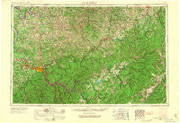
~ Charleston WV topo map, 1:250000 scale, 1 X 2 Degree, Historical, 1957, updated 1966
Charleston, West Virginia, USGS topographic map dated 1957.
Includes geographic coordinates (latitude and longitude). This topographic map is suitable for hiking, camping, and exploring, or framing it as a wall map.
Printed on-demand using high resolution imagery, on heavy weight and acid free paper, or alternatively on a variety of synthetic materials.
Topos available on paper, Waterproof, Poly, or Tyvek. Usually shipping rolled, unless combined with other folded maps in one order.
- Product Number: USGS-5416198
- Free digital map download (high-resolution, GeoPDF): Charleston, West Virginia (file size: 20 MB)
- Map Size: please refer to the dimensions of the GeoPDF map above
- Weight (paper map): ca. 55 grams
- Map Type: POD USGS Topographic Map
- Map Series: HTMC
- Map Verison: Historical
- Cell ID: 68709
- Scan ID: 701708
- Imprint Year: 1966
- Woodland Tint: Yes
- Edit Year: 1965
- Field Check Year: 1957
- Datum: Unstated
- Map Projection: Transverse Mercator
- Map published by United States Army
- Map Language: English
- Scanner Resolution: 508 dpi
- Map Cell Name: Charleston
- Grid size: 1 X 2 Degree
- Date on map: 1957
- Map Scale: 1:250000
- Geographical region: West Virginia, United States
Neighboring Maps:
All neighboring USGS topo maps are available for sale online at a variety of scales.
Spatial coverage:
Topo map Charleston, West Virginia, covers the geographical area associated the following places:
- Nelson - Silver Valley Estates - Marvel - Jamestown (historical) - Tango - Van Camp - Duffy - Wymer - Ravenseye - Goldtown - Little Otter - Mingo - Curtin - Bergoo - Gazil (historical) - Lyonsville - Glade View - Speed - German (historical) - Coalfield - Woods and Irons South - Corton - Lucile - Mulvane (historical) - Jimtown - Maysel - Rosina (historical) - Let (historical) - Big Otter - Vernon - Bryant (historical) - Letart Falls - Bower - Gauley - Annamoriah - Wildcat - Ripley - Saunders Addition - Aspinall - Spencer - Forest Hills - Avoca - Carbon - Hico - Ravenswood - Sandy Summit - Little Wildcat (historical) - Lovada - Marpleton - Upper Flats - Deepwell - Sissonville - Pickens - Brushton - Hereford - Spring Hill - Tad - Elkhurst - Blackburn - Harlem Heights - Rushville - Schilling Addition - Englewood Estates - Sanoma - Red Warrior - Spice - Keeneys Creek - Emmons - Wellford - Holly - Middle Run - Vandalia - Weberwood - Bolair - Big Run - Evergreen Hills - Romance - Belva - Cotton Hill - Kanawha Estates - Rollins - Groves - Evergreen - Blue Spring - Ortin Heights - Bennett - Sumerco - Olcott - Strawberry Heights - Finegan Ford - Glendon - Brush Camp Low Place - Sleith (historical) - Tipton - Pond Fork - Roseville Addition - Kirkwood - Thrash (historical) - Hopewell - Newton
- Map Area ID: AREA3938-82-80
- Northwest corner Lat/Long code: USGSNW39-82
- Northeast corner Lat/Long code: USGSNE39-80
- Southwest corner Lat/Long code: USGSSW38-82
- Southeast corner Lat/Long code: USGSSE38-80
- Northern map edge Latitude: 39
- Southern map edge Latitude: 38
- Western map edge Longitude: -82
- Eastern map edge Longitude: -80


