
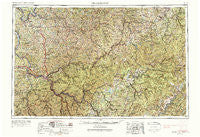
~ Charleston WV topo map, 1:250000 scale, 1 X 2 Degree, Historical, 1957, updated 1988
Charleston, West Virginia, USGS topographic map dated 1957.
Includes geographic coordinates (latitude and longitude). This topographic map is suitable for hiking, camping, and exploring, or framing it as a wall map.
Printed on-demand using high resolution imagery, on heavy weight and acid free paper, or alternatively on a variety of synthetic materials.
Topos available on paper, Waterproof, Poly, or Tyvek. Usually shipping rolled, unless combined with other folded maps in one order.
- Product Number: USGS-5416196
- Free digital map download (high-resolution, GeoPDF): Charleston, West Virginia (file size: 34 MB)
- Map Size: please refer to the dimensions of the GeoPDF map above
- Weight (paper map): ca. 55 grams
- Map Type: POD USGS Topographic Map
- Map Series: HTMC
- Map Verison: Historical
- Cell ID: 68709
- Scan ID: 254037
- Imprint Year: 1988
- Woodland Tint: Yes
- Photo Revision Year: 1965
- Field Check Year: 1957
- Datum: Unstated
- Map Projection: Transverse Mercator
- Map published by United States Geological Survey
- Map Language: English
- Scanner Resolution: 600 dpi
- Map Cell Name: Charleston
- Grid size: 1 X 2 Degree
- Date on map: 1957
- Map Scale: 1:250000
- Geographical region: West Virginia, United States
Neighboring Maps:
All neighboring USGS topo maps are available for sale online at a variety of scales.
Spatial coverage:
Topo map Charleston, West Virginia, covers the geographical area associated the following places:
- Kirbyton - Higby (historical) - Elmira - Liberty Hill - North Park - Lincoln Park - Suncrest - Elk Hills - Wymer - North Page - Andrew - Odaville - Hampton - Arbuckle - Putney - Bulltown - Emmons - Joplin - Villa (historical) - Tate - Leonard - Normantown - Keeneys Creek - Droop Mountain - East Bank - North Bend - Winfield - Bison - Sleepy Hollow Township - Newville - Elana - Summersville - Kanawha Falls - Morocco (historical) - Heizer - Bealls Mills - Teays Villa - Linden - Finster - Burnsville - Rhoda - Racine - Sago - Saxon - Mattie (historical) - Newton - Tallmansville - Coalfield - Henrietta - Nitro - Cornelia - Foch - Fayette Heights - Corley - Racine - Ruthdale - Mink (historical) - Winfield Mobile Home Park - Red Knob - Greendale - Pond Fork - Newlonton - Lory - Milliken - Legg - Rockton - Belle - Wildcat - Silverton - Roseville Addition - Mahan - Diamond - Nettie - Lower Belle - Paradise - Ramsey - Corton - Fairview - Marshall - Oka - Clover - Riverdale Estates - Campbelltown - Hilton Village - Clem - Muddlety - Thornhill Addition - Ingo - Boyd (historical) - Carl - Confidence - Wallback - Spiller - Linwood - Vandalia - Sumerco - Deegans - Oak Ridge - Abbott - Sterling (historical)
- Map Area ID: AREA3938-82-80
- Northwest corner Lat/Long code: USGSNW39-82
- Northeast corner Lat/Long code: USGSNE39-80
- Southwest corner Lat/Long code: USGSSW38-82
- Southeast corner Lat/Long code: USGSSE38-80
- Northern map edge Latitude: 39
- Southern map edge Latitude: 38
- Western map edge Longitude: -82
- Eastern map edge Longitude: -80


