
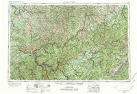
~ Charleston WV topo map, 1:250000 scale, 1 X 2 Degree, Historical, 1957, updated 1974
Charleston, West Virginia, USGS topographic map dated 1957.
Includes geographic coordinates (latitude and longitude). This topographic map is suitable for hiking, camping, and exploring, or framing it as a wall map.
Printed on-demand using high resolution imagery, on heavy weight and acid free paper, or alternatively on a variety of synthetic materials.
Topos available on paper, Waterproof, Poly, or Tyvek. Usually shipping rolled, unless combined with other folded maps in one order.
- Product Number: USGS-5416194
- Free digital map download (high-resolution, GeoPDF): Charleston, West Virginia (file size: 33 MB)
- Map Size: please refer to the dimensions of the GeoPDF map above
- Weight (paper map): ca. 55 grams
- Map Type: POD USGS Topographic Map
- Map Series: HTMC
- Map Verison: Historical
- Cell ID: 68709
- Scan ID: 254036
- Imprint Year: 1974
- Woodland Tint: Yes
- Photo Revision Year: 1965
- Field Check Year: 1957
- Datum: Unstated
- Map Projection: Transverse Mercator
- Map published by United States Geological Survey
- Map Language: English
- Scanner Resolution: 600 dpi
- Map Cell Name: Charleston
- Grid size: 1 X 2 Degree
- Date on map: 1957
- Map Scale: 1:250000
- Geographical region: West Virginia, United States
Neighboring Maps:
All neighboring USGS topo maps are available for sale online at a variety of scales.
Spatial coverage:
Topo map Charleston, West Virginia, covers the geographical area associated the following places:
- Blackburn - Bachman - Lick Fork - Peniel - Louther - Gazil (historical) - Campbell Addition - South Fayette - Imperial - Orgas - Blue Creek - Kester (historical) - Morning Star - Morrison (historical) - Kennison - Chimney Corner - Hillsboro - Milltown - Mount Nebo - Canaan - Fishers Crossing - Stumptown - Cutlips - Condeville - Walnut - Sanderson - Low Gap - Swandale - Emma - Otto - Glenville - Perkins - Camelot Village Mobile Home Park - Mingo - Knapp - Page - Ortin Heights - Aplin (historical) - Horrock - Sattes - Welch Glade - Dempsey - Ballard (historical) - Doddtown - Etowah - Sand Fork - Let (historical) - North Ravenswood - Harless - Goshen - Glasgow - Shelton - Weberwood - New Haven - Cuba - Donlan - Droop - West Montgomery - Morocco (historical) - Mammoth - Richardson - Hills Crossing - Sun Valley - Bryce - Gale - Cross Lanes - Lucas - Hansford - Carbondale - Amma - Boone (historical) - German (historical) - Grassy Falls - Zackville - Parchment Valley - Tango - Teays Valley - Finster - Oakwood Estates - Deanville - Middle Run - Monterville - Gauley Mills - Two Run - Creston Flats - White Pine - Scott Depot - Teays - Nuckolls - Giles - Sunnyside (historical) - Mount Tell - Mattie (historical) - Depue - Tate - Joppa - Pickens - Englewood Estates - Shock - Midway
- Map Area ID: AREA3938-82-80
- Northwest corner Lat/Long code: USGSNW39-82
- Northeast corner Lat/Long code: USGSNE39-80
- Southwest corner Lat/Long code: USGSSW38-82
- Southeast corner Lat/Long code: USGSSE38-80
- Northern map edge Latitude: 39
- Southern map edge Latitude: 38
- Western map edge Longitude: -82
- Eastern map edge Longitude: -80


