
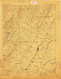
~ Winchester VA topo map, 1:125000 scale, 30 X 30 Minute, Historical, 1894, updated 1899
Winchester, Virginia, USGS topographic map dated 1894.
Includes geographic coordinates (latitude and longitude). This topographic map is suitable for hiking, camping, and exploring, or framing it as a wall map.
Printed on-demand using high resolution imagery, on heavy weight and acid free paper, or alternatively on a variety of synthetic materials.
Topos available on paper, Waterproof, Poly, or Tyvek. Usually shipping rolled, unless combined with other folded maps in one order.
- Product Number: USGS-5416170
- Free digital map download (high-resolution, GeoPDF): Winchester, Virginia (file size: 7 MB)
- Map Size: please refer to the dimensions of the GeoPDF map above
- Weight (paper map): ca. 55 grams
- Map Type: POD USGS Topographic Map
- Map Series: HTMC
- Map Verison: Historical
- Cell ID: 66958
- Scan ID: 189209
- Imprint Year: 1899
- Survey Year: 1885
- Datum: Unstated
- Map Projection: Unstated
- Map published by United States Geological Survey
- Map Language: English
- Scanner Resolution: 600 dpi
- Map Cell Name: Winchester
- Grid size: 30 X 30 Minute
- Date on map: 1894
- Map Scale: 1:125000
- Geographical region: Virginia, United States
Neighboring Maps:
All neighboring USGS topo maps are available for sale online at a variety of scales.
Spatial coverage:
Topo map Winchester, Virginia, covers the geographical area associated the following places:
- Apple View Estates - Round Hill - Chestnut Grove Estates - Kernstown - Jordan Springs - Gordondale - Welltown - Sunnyside - Milldale - Klines Mill - Senseny Heights - Darkesville - Capon Bridge - Cold Stream - Greenway Estates - Lakewood Acres - Layside Estates - White Post - Indian Lake - Fairway Heights - Bunker Hill - Hooks Mills - Ganotown - Albin - Goose Nest - Bunker Hill - Arcadia Mobile Home Park - Greenwood Heights - Bubbling Spring - Lake Frederick - Sir John Addition - Woodchuck Heights - Rosenberger - Light (historical) - De Haven - Nain - North Frederick Terrace - Waterloo Heights - Shenandoah Hills - Canterburg - Southwood Hills - Rolling Fields - De Haveland Estates - Payne Mobile Home Park - Ashby - Tarico Heights - Ash Hollow Estates - Nieswanders Fort - Frederick Heights - Mount Hope - Lehew - College Park - Leetown - Lost Corner - Claytonville - Dearmont Chase - Lebanon Church - Pyletown - Reliance - Hunters Valley - Neals Run - Cedar Hill - Nordic Village - Siler - Gore - Jericho (historical) - Shenandoah Mobile Home Park - Wilde Acres - Southview - Morton Grove - Nollville - Country Club Estates - High View Manor - Jones Springs - Shockeysville - Rest - Oakland - White Hall - Gerrardstown - Clear Brook - Waterloo - Shiloh (historical) - Country Park - Greenwood - Lincoln Estates - Greenway Court - Oranda - Cross Junction - Hayfield - Hogue Creek Estates - Gainesboro - Chambersville - Glengary - Mount Pleasant - Wheatfield - Union Corner - Shanghai - Meadow Mills - Echo Village - Stephenson
- Map Area ID: AREA39.539-78.5-78
- Northwest corner Lat/Long code: USGSNW39.5-78.5
- Northeast corner Lat/Long code: USGSNE39.5-78
- Southwest corner Lat/Long code: USGSSW39-78.5
- Southeast corner Lat/Long code: USGSSE39-78
- Northern map edge Latitude: 39.5
- Southern map edge Latitude: 39
- Western map edge Longitude: -78.5
- Eastern map edge Longitude: -78


