
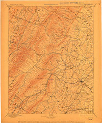
~ Staunton VA topo map, 1:125000 scale, 30 X 30 Minute, Historical, 1894, updated 1913
Staunton, Virginia, USGS topographic map dated 1894.
Includes geographic coordinates (latitude and longitude). This topographic map is suitable for hiking, camping, and exploring, or framing it as a wall map.
Printed on-demand using high resolution imagery, on heavy weight and acid free paper, or alternatively on a variety of synthetic materials.
Topos available on paper, Waterproof, Poly, or Tyvek. Usually shipping rolled, unless combined with other folded maps in one order.
- Product Number: USGS-5416166
- Free digital map download (high-resolution, GeoPDF): Staunton, Virginia (file size: 7 MB)
- Map Size: please refer to the dimensions of the GeoPDF map above
- Weight (paper map): ca. 55 grams
- Map Type: POD USGS Topographic Map
- Map Series: HTMC
- Map Verison: Historical
- Cell ID: 66689
- Scan ID: 701474
- Imprint Year: 1913
- Survey Year: 1887
- Datum: Unstated
- Map Projection: Unstated
- Map published by United States Geological Survey
- Map Language: English
- Scanner Resolution: 508 dpi
- Map Cell Name: Staunton
- Grid size: 30 X 30 Minute
- Date on map: 1894
- Map Scale: 1:125000
- Geographical region: Virginia, United States
Neighboring Maps:
All neighboring USGS topo maps are available for sale online at a variety of scales.
Spatial coverage:
Topo map Staunton, Virginia, covers the geographical area associated the following places:
- Briery Branch - Staunton - Greenville - Trimbles Mill - Barterbrook - Estaline - Shenandoah Valley Estates - Brand - Churchville - Cedar Green - Skymont - Folly Mills - Clover Hill - Jolivue - College Park - Centerville - Ottobine - Swoope - Fordwick - Little Baltimore - Middlebrook - Brookwood - White Hill - Roman - Snyder - McKinley - West Augusta - Sangerville - Craigsville - Bells Valley - Spring Hill - Palo Alto - Woodlee - Wilda - Peyton - Pond Gap (historical) - Plunkettsville - Mount Elliott Springs - Rivermont - Moscow - Selma - Doe Hill - Deerfield - Stribling Springs - Marble Valley - West View - McDowell - Spring Creek - Hebron - Liberty - Stokesville - West End - Verona - Stuarts Draft - North Mountain - Parnassus - Staunton Park - Stover - Ferrol - Millbrook - Mount Solon - Lilly - Newport - Avis - Buffalo Gap - Arbor Hill - Lone Fountain - Summerdean - Mount Pisgah - Christian - Chapin - Franks Mill - Dogwood Hill - Union Springs - Sirons Mill - Mint Spring - Augusta Springs - Quicks Mill
- Map Area ID: AREA38.538-79.5-79
- Northwest corner Lat/Long code: USGSNW38.5-79.5
- Northeast corner Lat/Long code: USGSNE38.5-79
- Southwest corner Lat/Long code: USGSSW38-79.5
- Southeast corner Lat/Long code: USGSSE38-79
- Northern map edge Latitude: 38.5
- Southern map edge Latitude: 38
- Western map edge Longitude: -79.5
- Eastern map edge Longitude: -79


